


Icebreaker Ships to Map Arctic Seafloor
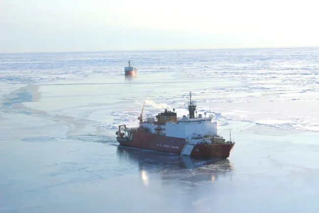
The U.S. icebreaker ship Healy is about to set sail on its way to the Arctic, where it will burst through the sea ice in order to map the seafloor below. The map will help set the record straight on how much of the seafloor a country can claim as its own.
The new map will also add to the growing set of information on the Earth's polar regions. Scientists are also mapping the hazards along Arctic shipping routes, which are expected to become more active as Arctic sea ice continues to melt. At the other end of the globe, NASA scientists recently created the most accurate map of the snaking line that marks the edge of the ice sheet covering much of Antarctica.
International law gives coastal nations the rights to the natural resources within 200 nautical miles from their coast (A nautical mile corresponds to about one minute of arc of latitude, or about 1.15 miles). This includes the seabed and subsoil — and all the minerals, petroleum and animals — on their slice of the continental shelf.
A country can stretch its reach into the so-called extended continental shelf, beyond 200 nautical miles, in certain situations, according to the U.N. Convention on the Law of the Sea. The new map will let countries know if and how far they can extend their reach, said Brian Edwards, chief scientist for the U.S. Geological Survey (USGS) aboard the U.S. Coast Guard Cutter Healy.
The Healy will sail from Aug. 2 to Sept. 6, meeting up with the Canadian Coast Guard Ship Louis S. St-Laurent at sea.
The ships will take turns breaking through the Arctic sea ice for each other. The Healy will map the shape of the seafloor, and the Louis S. St-Laurent will measure sediment thickness.
This is the third year the United States and Canada have collaborated in extended continental shelf data collection in the Arctic. The United States has been collecting its own icebreaker data in the Arctic since 2003.
Get the world’s most fascinating discoveries delivered straight to your inbox.
"The Arctic Ocean is an area of great interest for science, resource conservation, and possible economic development," said Deborah Hutchinson, a spokesperson for the USGS. "Because there is an area with considerable overlap between the U.S. and Canadian extended continental shelves, it makes sense to share data sets and work together in the remote and challenging environments of the Arctic Ocean."
- North vs.South Poles: 10 Wild Differences
- New Map to Help Calculate Antarctic Ice Loss
- World's Oceans Remain Largely Mysterious
This article was provided by OurAmazingPlanet, a sister site to LiveScience.
