This past summer, NASA launched its first satellite devoted to measuring atmospheric carbon dioxide, a heat-trapping gas that is driving global warming.
Today (Dec. 18), scientists with the space agency unveiled the first carbon maps obtained by the spacecraft, named the Orbiting Carbon Observatory-2, or OCO-2.
OCO-2 only started collecting its first scientifically useful information at the end of September, but the initial results "are quite amazing," said Annmarie Eldering, OCO-2 deputy project scientist, based at NASA's Jet Propulsion Laboratory in Pasadena, California. [In Photos: World's Most Polluted Places]
Latest Videos FromLive Science
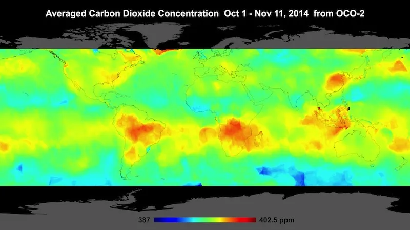
In a news conference at the annual meeting of the American Geophysical Union in San Francisco, Eldering and her colleagues showed a map of the globe that uses about 600,000 data points taken by OCO-2 from Oct. 1 through Nov. 17. It shows hotspots of carbon dioxide over northern Australia, southern Africa and eastern Brazil.
These carbon spikes could be explained by agricultural fires and land clearing — practices that are widespread during spring in the Southern Hemisphere, OCO-2 scientists said.
NASA scientists aren't just interested in learning more about the understudied effects of biomass burning. As OCO-2 collects more data, the scientists are hoping to compile the most complete picture to date of how carbon dioxide is distributed — geographically and seasonally. They'll also look at the places where that carbon dioxide is removed.
"We feel certain that once we have a larger data set with this kind of density and precision, it will really be valuable to the scientific community and to understand the carbon dioxide fluxes," Eldering said.
OCO-2 launched on July 2 from Vandenberg Air Force Base in California, carried aloft by a United Launch Alliance Delta 2 rocket. About a month later, the spacecraft reached its final, near-polar orbit 438 miles (705 kilometers) above Earth. The $465-million mission was more than a decade in the making. The original OCO spacecraft crashed into the Pacific Ocean in February 2009, after a failure with its rocket.
What sets OCO-2 apart from past spacecraft, such as Japan's Greenhouse Gases Observing Satellite (GOSAT), is the amount of data it can collect.
The satellite has a grading spectrometer to measure carbon dioxide levels with a precision of about 1 part per million, or ppm. (Today's carbon concentration, 400 ppm, is the highest in at least 800,000 years. This number means there are 400 molecules of carbon dioxide in the air per every million air molecules. Before the Industrial Revolution, carbon concentration was thought to be about 280 ppm.)
OCO-2 takes about a million measurements each day, generating tens of thousands of useful data points. (Some data has to be thrown out because of cloud cover and uneven elevations.) And, the satellite can cover the entire globe in 16 days. While this is not the right scale to link an individual source (such as a specific event at a power plant or factory) to a spike in carbon emissions in a given area, the mission scientists say they are more focused on understanding the carbon cycle on a regional, monthly scale.
Follow Megan Gannon on Twitter and Google+. Follow us @livescience, Facebook & Google+. Original article on Live Science.