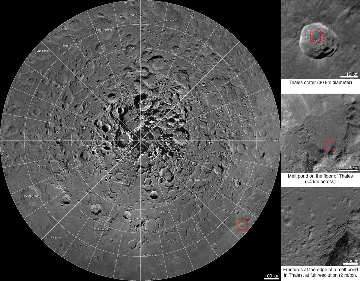
A new mosaic from NASA's Lunar Reconnaissance Orbiter showcases the north pole in high resolution. The images run from 60 to 90 degrees north latitude, with a resolution of 6.5 feet (2 meters) per pixel. At right are images of the Thales crater.
(Image credit: NASA/GSFC/Arizona State University)
A new high-resolution map of the moon's north pole shows a view of the surface that even the Apollo astronauts would envy.
The new lunar mosaic — which was captured by NASA's Lunar Reconnaissance Orbiter (LRO) — resolves features as small as 6.5 feet (2 meters), providing information that could be used for landing-site scouting or to answer various questions about the surface of the moon, agency officials said.
With scientists and the public able to click, zoom in and move around the map, it's the first time an interactive mosaic has been released of the moon's north pole. [See the new moon map and more lunar photos from LRO]
"Creation of this giant mosaic took four years and a huge team effort across the LRO project," Mark Robinson, principal investigator for the Lunar Reconnaissance Orbiter Camera, said in a statement.
"We now have a nearly uniform map to unravel key science questions and find the best landing spots for future exploration," added Robinson, who is based at Arizona State University in Tempe.
The mosaic is made up of 10,581 pictures carefully selected to provide consistent lighting across the surface. The map, which is hundreds of billions of pixels in size, gives a high-definition view of craters, divots and shadows across an area more than one-quarter that of the United States.
If you were to print out the map at the standard for print publications (300 dots per inch), it would be almost the same size as a U.S. football field, NASA officials said.
Sign up for the Live Science daily newsletter now
Get the world’s most fascinating discoveries delivered straight to your inbox.
Images were obtained by the Lunar Reconnaissance Orbiter Camera, supplemented with data from LRO's Lunar Orbiter Laser Altimeter instrument. Map creators also used data from NASA's Gravity Recovery and Interior Laboratory (GRAIL) mission.
GRAIL's twin spacecraft (called Ebb and Flow) made the highest-resolution gravity map ever of the moon before smashing as planned into a lunar mountain in December 2012.
NASA's Lunar Reconnaissance Orbiter has been circling the moon since June 2009, using seven instruments to examine the lunar surface and its radiation. Among the probe's notable achievements is finding extensive evidence of water iceon the moon's surface.
Elizabeth Howell was staff reporter at Space.com between 2022 and 2024 and a regular contributor to Live Science and Space.com between 2012 and 2022. Elizabeth's reporting includes multiple exclusives with the White House, speaking several times with the International Space Station, witnessing five human spaceflight launches on two continents, flying parabolic, working inside a spacesuit, and participating in a simulated Mars mission. Her latest book, "Why Am I Taller?" (ECW Press, 2022) is co-written with astronaut Dave Williams.