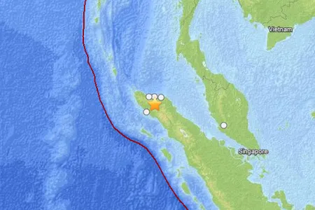
A powerful earthquake of preliminary magnitude 6.1 struck today in Indonesia, according to the U.S. Geological Survey (USGS).
The temblor's epicenter was 34 miles (55 km) south of Bireun, Indonesia, on the northern end of the island of Sumatra. It originated 6.2 miles (10 km) deep and struck at 2:37 p.m. local time (7:37 UTC), the USGS reports.
Dozens were injured and at least one person was killed in Indonesia's Aceh province after the earthquake damaged houses and triggered a landslide, according to the Associated Press.
Latest Videos From
Earthquakes of this size can cause significant damage, especially with poorly built structures. Even well designed buildings can be damaged or, in some cases, destroyed depending on the severity of the quake and a building’s proximity to the epicenter. Earthquakes of this size are sometimes followed by significant aftershocks. But the damage caused by any single event depends on the quake's depth, proximity to populated areas, building standards in the region, as well as the type of earthquake. The USGS frequently updates the magnitude of an event after more data is analyzed.
An earthquake's magnitude is a measure of the energy released at the source. It is just one predictor of the shaking that may ensue, which is affected by local and regional geology. Scientists know in a general sense what causes Earthquakes but are unable to predict specific quakes.
This article will be updated if significant additional information becomes available. Find more earthquake news here.

 Live Science Plus