It's quick and easy to access Live Science Plus, simply enter your email below. We'll send you a confirmation and sign you up for our daily newsletter, keeping you up to date with the latest science news.
Those unwilling to face the altitude sickness, crevasses and avalanches of Mount Everest can still explore the world's highest mountain from home.
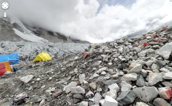
Google Maps has unveiled stunning, panoramic imagery from some of the highest, most remote places on Earth, including the 18,192-foot-high (5,545 meters) Mount Everest base camp. (Everest's peak is at an altitude of 29,035 feet, or 8,850 meters)
The maps now include 360-degree views of four of the seven summits, the highest peaks on all seven continents. Users can virtually hike snow-covered Mount Elbrus, the highest peak in Europe, hang out at the Plaza Argentina base camp at Aconcagua, the highest peak in the Andes Mountains, and walk amid the clouds at the base camp for the world's tallest peak.
The new imagery also includes a 360-degree view of the snow-capped Mt. Elbrus, the tallest mountain in Europe
(Image credit: Google Maps)
The new imagery also allows users to climb 19,341 feet (5,895 m) to Mount Kilimanjaro's Uhuru, the highest point in Africa. Mount Kilimanjaro is actually a stratovolcano that formed about a million years ago from layers and layers of volcanic ash, lava, pumice and tephra.
To capture the photos, the team used a lightweight camera and tripod with a fish-eye lens.
In 2011, the Google Maps team spent 12 days, hiked more than 70 miles (113 kilometers) and reached an altitude of 18,192 feet at the Everest base camp. As part of the process, they faced earthquakes, flash floods and mudslides, Sara Pelosi, a manager at the company, wrote on Google's lat-long blog.
Sign up for the Live Science daily newsletter now
Get the world’s most fascinating discoveries delivered straight to your inbox.
The images can be viewed in Google Maps on iPhones or Android phones.
Tia is the editor-in-chief (premium) and was formerly managing editor and senior writer for Live Science. Her work has appeared in Scientific American, Wired.com, Science News and other outlets. She holds a master's degree in bioengineering from the University of Washington, a graduate certificate in science writing from UC Santa Cruz and a bachelor's degree in mechanical engineering from the University of Texas at Austin. Tia was part of a team at the Milwaukee Journal Sentinel that published the Empty Cradles series on preterm births, which won multiple awards, including the 2012 Casey Medal for Meritorious Journalism.

 Live Science Plus