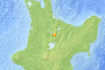
An earthquake of preliminary magnitude 6.3 struck New Zealand's North Island today, according to the U.S. Geological Survey (USGS).
The temblor's epicenter was 12 miles (19 km) southeast of the town of Tokoroa and 214 miles (345 km) north-northeast of the capital Wellington. It originated 103 miles (167 km) deep and struck at 7:19 a.m. local time Saturday (1819 UTC Friday), the USGS reports.
Earthquakes of this size can cause significant damage, especially with poorly built structures. Even well designed buildings can be damaged or, in some cases, destroyed depending on the severity of the quake and a building’s proximity to the epicenter. Earthquakes of this size are sometimes followed by significant aftershocks.
Latest Videos From
But the damage caused by any single event depends on the quake's depth, proximity to populated areas, building standards in the region, as well as the type of earthquake. The USGS frequently updates the magnitude of an event after more data is analyzed.
An earthquake's magnitude is a measure of the energy released at the source. It is just one predictor of the shaking that may ensue, which is affected by local and regional geology. Scientists know in a general sense what causes Earthquakes but are unable to predict specific quakes.
This article will be updated if significant additional information becomes available. Find more earthquake news here.