It's quick and easy to access Live Science Plus, simply enter your email below. We'll send you a confirmation and sign you up for our daily newsletter, keeping you up to date with the latest science news.
Get the world’s most fascinating discoveries delivered straight to your inbox.
You are now subscribed
Your newsletter sign-up was successful
Want to add more newsletters?
Join the club
Get full access to premium articles, exclusive features and a growing list of member rewards.
An account already exists for this email address, please log in.
Rare Fujiwhara hurricane 'dance' could save East Coast from worst effects of Tropical Storm Imelda
Forecasters expect Hurricane Humberto to pull Tropical Storm Imelda away from landfall and into a Fujiwhara dance, but the East Coast is still set to experience heavy rains and life-threatening rip currents.
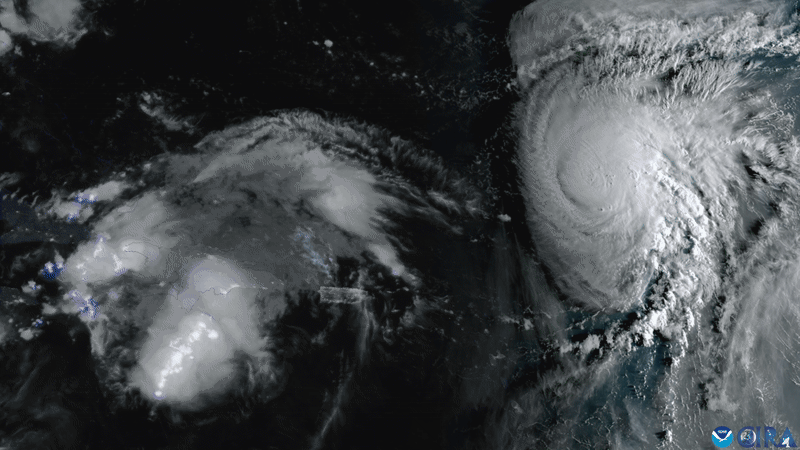
Hurricane Humberto (on the right) is expected to pull Tropical Storm Imelda (developing on the left) away from the East Coast. This GOES-19 satellite image was taken on Friday, before Imelda strengthened into a named tropical storm.
Two hurricanes could "dance" in the Atlantic this week as forecasters warn of life-threatening surf and rip currents along the East Coast. However, if the duo does dance, that could actually save the East Coast from the potentially catastrophic rainfall one of the storms would normally bring.
Tropical Storm Imelda is currently passing over the northwestern Bahamas and is expected to intensify into a hurricane on Tuesday (Sept. 30), according to the National Hurricane Center (NHC). Meanwhile, hundreds of miles offshore, Hurricane Humberto continues to rage after reaching Category 5 hurricane status on Saturday (Sept. 27).
The two storms could potentially swirl around each other in a hurricane "dance" called the Fujiwhara Effect, named after Japanese meteorologist Sakuhei Fujiwhara, Accuweather reported on Friday (Sept. 26). However, this rare weather phenomenon is complex and difficult for forecasters to model.
As things stand, Imelda is expected to move off the Bahamas and out to sea. Forecasters predict that the strength of Hurricane Humberto will drag Imelda east-northeast, so that it swings away from the East Coast, and toward Humberto.
"The rare Fujiwhara Effect between Humberto and Imedla is expected to help spare the southeast U.S. from widespread flooding rainfall," Alex DaSilva, the lead hurricane expert at AccuWeather, said in an emailed statement. "The influence from the much stronger and larger Humberto will tug at Imelda and help pull the storm away from the U.S. and out to sea."
Imelda is expected to contribute to heavy rain from Florida to North Carolina and southern Virginia, while both storms will likely generate dangerous rip currents from South Florida to the mid-Atlantic, the NHC has warned. Humberto will likely cause flash flooding in the northwestern Bahamas and eastern Cuba, with the potential for mudslides in Cuba, it reported.
Get the world’s most fascinating discoveries delivered straight to your inbox.
The United Nations' World Meteorological Organization names tropical storms when they have maximum sustained wind speeds of more than 39 mph (63 km/h). Imelda crossed that threshold on Sunday (Sept. 28), and currently has maximum sustained wind speeds of 50 mph (85 km/h), according to the NHC.
To become a hurricane, Imelda's wind speeds will need to reach 74 mph (119 km/h) or greater, which is expected to happen on Tuesday. There are five categories of hurricane, measured against the Saffir-Simpson Wind Scale, based on the severity of the maximum sustained wind speeds.
Hurricane Humberto strengthened into a major hurricane on Friday (Sept. 26).
(Image credit: CSU/CIRA & NOAA)
Hurricane Humberto formed on Sept. 24 and continued to strengthen until it topped the hurricane scale at Category 5 on Saturday (Sept. 27), with maximum sustained winds of 160 mph (260 km/h). The hurricane is currently a Category 4 and is heading west with a similar strength and trajectory to Hurricane Erin, a previous Category 5 Atlantic hurricane that formed in August.
Hurricane Humberto and potential hurricane Imelda will come within 700 miles (1,100 kilometers) of each other during their closest pass, according to DaSilva. While the East Coast will still feel impacts from the storms, it could have been much worse.
"It's quite rare to see the Fujiwhara Effect in the Atlantic basin," DaSilva said. "The interaction between the two storms should prevent Imelda from making landfall or stalling near the coast, which could have led to days of torrential rainfall and widespread flooding. The impacts could have been catastrophic."
When two tropical storms meet during a Fujiwhara event, they don't simply bash into each other. The most likely Fujiwhara scenario is for one storm to get absorbed by the other. In this scenario, the storms could briefly rotate around each other before the smaller of the two gets sucked into, and becomes part of, the larger storm, Accuweather reported.
The Fujiwhara scenario can, on rare occasions, have an additive outcome, where the two hurricanes merge to become a more powerful single storm, according to the National Weather Service. Alternatively, two clashing storms can also just rotate around each other before spinning off in different directions.
Patrick Pester is the trending news writer at Live Science. His work has appeared on other science websites, such as BBC Science Focus and Scientific American. Patrick retrained as a journalist after spending his early career working in zoos and wildlife conservation. He was awarded the Master's Excellence Scholarship to study at Cardiff University where he completed a master's degree in international journalism. He also has a second master's degree in biodiversity, evolution and conservation in action from Middlesex University London. When he isn't writing news, Patrick investigates the sale of human remains.
You must confirm your public display name before commenting
Please logout and then login again, you will then be prompted to enter your display name.