
 Live Science Plus


Hurricane Matthew: Where Is This Massive Storm Heading?

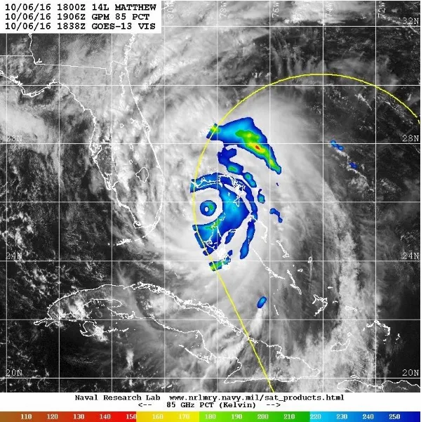
Update (Oct. 7 at 10:01 a.m. ET): Hurricane Matthew weakened slightly into a Category 3 hurricane, and is now sustaining winds of 120 mph (195 km/h), but experts still consider it dangerous as it moves up the eastern Florida coast. The storm is moving north-northwest today at 13 mph (20 km/h), and is expected to reach the coasts of Georgia and South Carolina on Saturday (Oct. 8), according to an update released by the National Hurricane Center (NHC) at 8 a.m. ET today (Oct. 7).
Those areas will probably see rain bands long before Saturday, as hurricane-force winds extend outward up to 60 miles (95 km) from the center of the storm, and tropical-storm-force winds extend up to 185 miles (295 km) from the center. Cape Canaveral, Florida, which was north of the hurricane this morning, reported wind gusts of up to 97 mph (155 km/h), the NHC said.
The hurricane is also bringing rain, with an expected 8 to 12 inches (20 to 30 centimeters) over the Atlantic coast, from central Florida to eastern North Carolina, the NHC said. After reaching the top of North Carolina, Matthew is expected to turn east and go out to sea. [50 Amazing Hurricane Facts]

Reports are now coming in that Hurricane Matthew killed more than 300 people in Haiti, largely in towns and fishing villages along the southern coast, according to the BBC. Meanwhile, Gov. Rick Scott in Florida urged people to evacuate, and the Walt Disney World, Universal Studios and SeaWorld theme parks in Orlando are closed for the storm, the BBC said.
—Get the latest information on Hurricane Matthew at the National Hurricane Center.
—See images of Hurricane Matthew and the devastation it left behind.
Update (Oct. 6 at 10:29 a.m. ET): Hurricane Matthew, now classified as a Category 3 hurricane with 125 mph (205 km/h) winds, is expected to reach the eastern coast of Florida late today (Oct. 6) and then move northward, hugging the Florida coast through Friday night, according to an update from the National Hurricane Center (NHC) released at 8 a.m. EDT today.
Get the world’s most fascinating discoveries delivered straight to your inbox.
The storm passed through Haiti, Cuba and most of the Bahamas these past few days, leaving torrential rain and flooding in its path. It's unclear how many people have died, but initial reports have the count at five in Haiti and four in the Dominican Republic, according to the Washington Post.
Matthew is currently moving northwest at 12 mph (19 km/h), and is expected to strengthen, regaining its Category 4 status as it reaches Florida, the NHC said. Hurricane-force winds extend 40 miles (65 kilometers) from its center, and tropical-storm-force winds extend up to 160 miles (260 km) from its center, the NRC reported. [See Photos of Hurricane Matthew]
There may, however, be good news for the Mid-Atlantic and New England states. Forecast models now show that after Hurricane Matthew reaches the Carolinas, it may head east into the Atlantic Ocean, sparing the northern states, according to NHC graphics and a report from The Weather Channel.
Update (Oct. 5 at 10:24 a.m. ET): After passing over Haiti and eastern Cuba yesterday (Oct. 4), Hurricane Matthew is heading for the central and northwestern Bahamas, according to an update released by the National Hurricane Center (NHC) at 8 a.m. EDT today (Oct. 5).
The hurricane now has sustained winds of about 115 mph (185 km/h), making it a Category 3 hurricane, the NHC reported. It's moving to the north-northwest at about 10 mph (17 km/h), and has hurricane-force winds extending outward up to 40 miles (65 kilometers) from its center, and tropical-force winds extending outward up to 160 miles (260 km), the NHC said.
Matthew is expected to make a northwest turn tonight, putting it on track to move across the Bahamas through Thursday, and then be "very near the east coast of Florida by Thursday evening," bringing intense winds, rain and flooding, the center said.
Original article published on Oct. 4, at 4:50 p.m. ET.
Hurricane Matthew is battering Haiti with powerful winds and extreme rain today (Oct. 4), with forecasts indicating it could cross the country and hit eastern Cuba next, according to the National Hurricane Center (NHC). With the Bahamas and possibly Florida and the Carolinas within the storm's path in the coming days, how bad could Hurricane Matthew get?
When Hurricane Matthew made landfall in southwestern Haiti this morning, it had wind speeds of 145 mph (233 km/h), making it a Category 4 hurricane, the NHC said in a public advisory. The storm is now moving northward at 10 mph (16 km/h), according to the NHC.
"We have it as a Category 4 hurricane for the next 48 hours, which means as it's going through the Bahamas, it's likely to be a Category 4 hurricane and then weaken into a Category 3 hurricane as it's off of the northeastern and east central coasts of Florida," said Jack Beven, a senior hurricane specialist at the National Hurricane Center in Florida. [Hurricanes from Above: Images of Nature's Biggest Storms]
There's even a chance that Matthew could continue its northward course and affect some states in the Mid-Atlantic and New England, Beven said.
"It could be a nor'easter-type blow by that time," he told Live Science. "I doubt it's going to be the reincarnation of [Hurricane] Sandy, but right now, it's just too early to say what kind of a structure and impact it will have."
In case the hurricane does hit Florida, the NHC issued a hurricane watch from Deerfield Beach, Florida, to the Volusia and Brevard County line, the NHC said. There is a tropical storm watch in effect for the Lake Okeechobee area and from Seven Mile Bridge in the Florida Keys northward to the area south of Deerfield Beach, which includes Fort Lauderdale and Miami, according to the NHC.

However, it's not clear yet when the hurricane may arrive. If it's coming toward the southern part of the state, it's expected to hit Thursday (Oct. 6), but if it moves more toward central and northern Florida, it may arrive Friday (Oct. 7), Beven said.
Matthew may weaken if and when it reaches the Carolinas, "although it could still be a major hurricane," Beven said. "The actual forecast track does have it briefly making landfall up in that area," he added. "So, we'll have to watch for that possibility, but that's four days down the road, so there's a lot of uncertainty."
Matthew and Nicole
Hurricane Matthew isn't alone. Today, the NHC reported that Tropical Storm Nicole, located farther east in the Atlantic than Matthew, has 50 mph (80 km/h) winds and is moving northwest at 8 mph (13 km/h).
There's a chance that Matthew and Nicole could interact, said James Done, the science lead for the Capacity Center for Climate and Weather Extremes at the National Center for Atmospheric Research in Boulder, Colorado. [5 Hurricane Categories: Historical Examples]
"There's a possibility that Nicole could pull Matthew away from the U.S., but that depends on a lot of factors, including the relative intensity of each storm and how close they are to one another," Done told Live Science.
Weather conditions also may impact how Matthew and Nicole progress, Done said.
"Generally, [hurricanes] like moist, calm conditions with a warm ocean," he said. "We definitely had a warm ocean. The ocean in the Caribbean right now is warmer than normal for this time of year, and the warmth extends to great depths."
He added that "it's likely a portion of the warming is due to human activity — [so-called] anthropogenic climate change."
Tropical Storm Nicole isn't the only system that may affect Hurricane Matthew. There's also a trough of low pressure moving eastward across the United States this week, Done said. If the trough moves quickly, it could arrive at the East Coast in time to guide Matthew harmlessly out to sea, but it's still unclear whether that will happen, he said. Moreover, ocean temperatures typically cool down north of Cape Hatteras, the part of North Carolina that sticks out into the Atlantic, he said, and those cooler temperatures could weaken the storm.
Original article on Live Science.

Laura is the managing editor at Live Science. She also runs the archaeology section and the Life's Little Mysteries series. Her work has appeared in The New York Times, Scholastic, Popular Science and Spectrum, a site on autism research. She has won multiple awards from the Society of Professional Journalists and the Washington Newspaper Publishers Association for her reporting at a weekly newspaper near Seattle. Laura holds a bachelor's degree in English literature and psychology from Washington University in St. Louis and a master's degree in science writing from NYU.