
 Live Science Plus


What Made Hurricane Matthew So Strong?


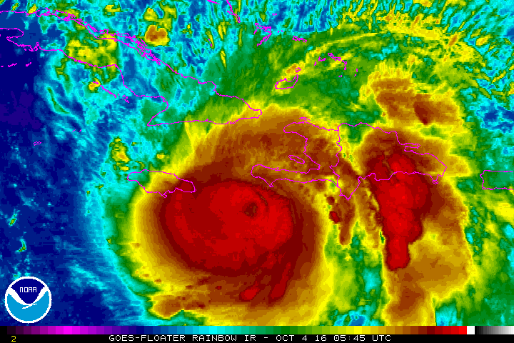
As powerhouse Hurricane Matthew continues on its slow but steady track across the Caribbean toward Haiti, Jamaica and Cuba, experts caution that the storm's impact could be devastating.
The 13th named storm of the 2016 Atlantic hurricane season is also the strongest storm since Hurricane Felix in 2007. Matthew briefly reached Category 5 hurricane status — with winds exceeding 157 mph (252 km/h) — on Oct. 1, NASA reported. Matthew dropped to Category 4 strength soon after, with maximum sustained winds calculated at a still-dizzying 140 mph (225 km/h) on Oct. 3. And high-speed winds are only part of the threat that the storm poses to Haiti, with storm surges and "life-threatening rain" also anticipated, according to the National Hurricane Center (NHC) in Florida. [Hurricanes from Above: Images of Nature's Biggest Storms]
The NHC describes Category 4 storms as producing "catastrophic damage" -- snapping and uprooting trees, severely damaging even well-built homes, causing sustained power outages, and rendering much of the area in the hurricane's path uninhabitable, perhaps for months.
So what's making Matthew such a beast, and what needs to happen for hurricanes to reach this level of intensity?
The perfect storm
Storms as strong as Matthew are rare in the Atlantic, Caribbean and Gulf of Mexico, and for hurricanes to build up to Matthew's current intensity, several conditions must be met, according to Chris Lancey, a science and operations officer at the NHC.
Lancey told Live Science that there are several key "ingredients" in the recipe for a powerful hurricane. The first requirement is warm ocean water — "the warmer the better," Lancey said. And it can't just be a shallow layer at the ocean surface, he added. Warm water provides the energy that fuels a growing tropical storm — the higher the water temperature and the more warm water there is, the more energy the storm has to tap into, and the faster its winds can blow.
Another important factor that fuels hurricane strength is an abundance of moist air. While hurricanes form in the tropics — where moist air is generally abundant — dry air originating over Africa and western Europe frequently finds its way into hurricanes and weakens them, Lancey explained.
Get the world’s most fascinating discoveries delivered straight to your inbox.
"If dry air is sucked into a hurricane, it disrupts the thunderstorm activity and causes them to stutter," he said.
The final variables that can make or break a hurricane are wind shear — rapid changes in wind speed or direction at certain atmospheric heights — and whether it hits land. In both cases, the hurricane's structure is disrupted, which weakens it. For a hurricane to reach Category 4 or Category 5 strength, all of these variables must come together at the same time — and that simply doesn't happen very often, Lancey told Live Science.
However, much of the damage Matthew is expected to inflict on Haiti, in particular, will not be due to the high wind speeds, but rather a staggering amount of rainfall, with forecasts predicting 15 to 25 inches (38 to 64 centimeters) over the next few days.
"In Haiti, the biggest factor for loss of life is flash floods and mudslides," Lancey said. "Portions of Haiti are very deforested, which makes flooding worse. A lot of people are living in river valleys that fill up with water; there could be a lot of people hurt or killed when Hurricane Matthew comes through there."
Currently, Matthew is tracking northward and approaching southwestern Haiti, the NHC reported. The storm is expected to continue toward eastern Cuba and reach southeastern parts of the Bahamas on Oct. 5.
Original article on Live Science.

Mindy Weisberger is a science journalist and author of "Rise of the Zombie Bugs: The Surprising Science of Parasitic Mind-Control" (Hopkins Press). She formerly edited for Scholastic and was a channel editor and senior writer for Live Science. She has reported on general science, covering climate change, paleontology, biology and space. Mindy studied film at Columbia University; prior to LS, she produced, wrote and directed media for the American Museum of Natural History in NYC. Her videos about dinosaurs, astrophysics, biodiversity and evolution appear in museums and science centers worldwide, earning awards such as the CINE Golden Eagle and the Communicator Award of Excellence. Her writing has also appeared in Scientific American, The Washington Post, How It Works Magazine and CNN.