It's quick and easy to access Live Science Plus, simply enter your email below. We'll send you a confirmation and sign you up for our daily newsletter, keeping you up to date with the latest science news.
Get the world’s most fascinating discoveries delivered straight to your inbox.
You are now subscribed
Your newsletter sign-up was successful
Want to add more newsletters?
Join the club
Get full access to premium articles, exclusive features and a growing list of member rewards.
An account already exists for this email address, please log in.
Category 4 Hurricane Kiko is heading for Hawaii — but it will weaken before it gets there, forecasters say
Weather predictions show that Hurricane Kiko could hit Hawaii next week, but forecasters say the Category 4 storm will weaken to a tropical storm or low-category hurricane this weekend.
A Category 4 hurricane in the eastern Pacific Ocean could hit Hawaii early next week, but it will weaken considerably before it gets there, storm predictions show.
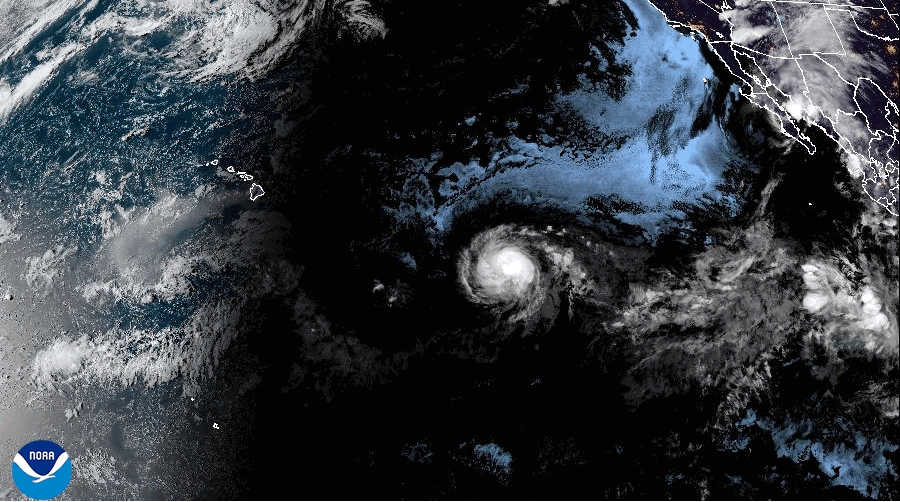
Hurricane Kiko rapidly intensified from a tropical storm on Monday (Sept. 1) to a Category 4 hurricane on Wednesday (Sept. 3), according to The Weather Channel. The storm is moving westward and currently tracking across a region of warm water and low wind shear roughly 1,300 miles (2,100 kilometers) southeast of Hawaii, meaning it could strengthen in the next few hours, forecasters said.
The latest National Hurricane Center (NHC) forecast suggests Hurricane Kiko is heading for Hawaii and may reach the islands by Tuesday or Wednesday next week (Sept. 9 or 10). Kiko is whipping up winds of up to 145 mph (230 km/h), according to a CNN video — but meteorologists predict that these gusts will weaken over the weekend to the levels of a tropical storm or low-category hurricane.
Kiko is "yet another example of a hurricane undergoing rapid intensification amongst extremely warm waters," Brandon Miller, a senior meteorologist and supervising weather producer for CNN, said in the video. However, it's highly unlikely that the storm will remain as powerful as it is now through Sept. 9 or 10, Miller said, because it has to pass through a patch of relatively cold water and trade winds first.
Hurricane Kiko will likely hit the cool, windy patch on Sunday (Sept. 7), which will reduce some of the storm’s intensity, according to The Weather Channel. Pockets of dry air hovering to the east of Hawaii will further slow the storm and Kiko will also be forced to cross wind shear that will cut the ground from under its feet.
It's possible that Hurricane Kiko will miss Hawaii entirely, as the storm is expected to gain latitude through early next week. A "cone of uncertainty" shared by the NHC — which sums up the different paths that Hurricane Kiko might follow in the shape of an elongated, sideways teardrop — shows that Kiko's center track could move north of Hawaii, which would avert some of the storm's worst impacts on the archipelago.
Get the world’s most fascinating discoveries delivered straight to your inbox.
Hurricane Kiko could make landfall in Hawaii early next week, but it could also pass by the islands.
(Image credit: National Hurricane Center/NOAA)
But hurricanes don't have to make landfall to bring bad weather. "Don't let your guard down, Hawaiians," Miller said. "Kiko could still bring impacts to the island, such as flooding rainfall and gusty winds."
Swells caused by the storm could reach Hawaiian shores toward the end of the weekend, generating potentially life-threatening surf and rip currents, The Weather Channel warned. Many of the Hawaiian Islands also still sit within the NHC's uncertainty cone.
The distance between Kiko's center track and Hawaii's individual islands will determine how severe the impacts on those islands will be, according to The Weather Channel.
Residents should therefore check updates regularly and stay informed, forecasters said.
Sascha is a U.K.-based staff writer at Live Science. She holds a bachelor’s degree in biology from the University of Southampton in England and a master’s degree in science communication from Imperial College London. Her work has appeared in The Guardian and the health website Zoe. Besides writing, she enjoys playing tennis, bread-making and browsing second-hand shops for hidden gems.
You must confirm your public display name before commenting
Please logout and then login again, you will then be prompted to enter your display name.

 Live Science Plus