


Hurricane Hunting Drones Probe Storms' Anatomy
WALLOPS ISLAND, Va. — Off the coast of Bermuda, in the North Atlantic Ocean, Tropical Storm Gabrielle is churning. More than 700 miles (1,100 kilometers) away, here on a quiet island on the East Coast of the United States, NASA scientists on Tuesday (Sept. 10) were preparing to study the storm, using a drone that can fly above the swirling mass of clouds to examine how they form and grow.
NASA's Global Hawk airplanes are designed to help researchers peer inside hurricanes and tropical storms, enabling them to witness the life cycles of these extreme weather events. These observations will assist scientists in developing more accurate models projecting the path of these storms, and determine whether or not they will gather strength.
"Forecasting the tracks of hurricanes has improved over the last several decades," said Scott Braun, the patriarch and principal investigator of NASA's Hurricane and Severe Storm Sentinel, or HS3, mission. "That's because, for the most part, the track is governed by large-scale winds that steer the storm, and we've gotten better and better observations over the years, and [we have] better models for predicting the track. Intensification, though, is a much more difficult problem." [In Photos: NASA's Global Hawk Hurricane Drones]
This is because a storm's intensity is driven by multiple factors, ranging from large-scale elements — such as the same storm-steering winds used to map a hurricane's track — to smaller-scale and more localized features that occur across only a few hundred kilometers, such as how individual clouds organize themselves into bigger cloud systems, Braun explained.
"Small-scale effects are difficult to observe in space and time," Braun told LiveScience. "Part of the reason for flying the aircraft over, or into, these storms is to get more information about what's happening inside the storms, and how they contribute to storm formation and intensification."
Eyes in the sky
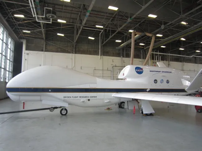
The Global Hawk drones are built to fly at altitudes higher than 55,000 feet (16,700 meters), and are capable of performing long flights that can last up to 30 hours. The bodies and V-shaped tails of the all-white planes are relatively small, but these drones boast incredible 116-foot (35-meter) wingspans. Radar and microwave instruments are housed in the planes' rounded nose and along their slender bellies.
Get the world’s most fascinating discoveries delivered straight to your inbox.
At NASA's facility here on Wallops Island, the HS3 mission operates two Global Hawks: one to observe the storm's environment, and the other to study the structures and processes within.
The combined altitude and duration of Global Hawk flights are what make their observations so valuable to scientists, said Chris Naftel, the soft-spoken but judicious project manager who oversees the Global Hawk program from NASA's Dryden Flight Research Center in Edwards, Calif. The drones also boast impressive range, being able to cover much of the western Atlantic Ocean and Gulf of Mexico from Wallops Island. [Image Gallery: Hurricane Season 2013]
"Our advantage is we can follow a storm for 18 to 20 hours, and get continuous coverage," Naftel said. "Scientists can also get all that data in real-time."

On Tuesday morning, Braun and his colleagues planned for a 22-hour Global Hawk mission to study Tropical Storm Gabrielle.
The drone sped down the runway and took off into the pristine blue sky shortly before 10 a.m. EDT (7 a.m. PDT). But 40 minutes into the flight, mission operators discovered that one of the plane's four navigation systems had failed. Despite having three other functioning systems onboard, the HS3 team decided to command the Global Hawk to turn around and return to its base in Virginia.
"The rules for this situation is that we return and land as soon as possible," Naftel said.
But, since the plane was outfitted to fly a 22-hour mission, it was still loaded with heavy fuel. To prepare for the early landing, Global Hawk pilots programmed the drone to fly laps over the ocean to burn off some of the fuel.
Naftel is unsure what caused the glitch in the navigation system, but said the unit will be switched out with a spare once the Global Hawk is on the ground again. Engineers will troubleshoot the failed system, and the flight over Gabrielle will likely be rescheduled for later this week.
Watching the Atlantic basin
NASA scientists have been flying Global Hawks over Gabrielle since before the tropical storm officially formed south of Puerto Rico a week ago, but the storm quickly petered out, and was downgraded to a tropical depression a day later. But the once-disorganized storm re-formed over the Atlantic Ocean earlier this week, and battered Bermuda with heavy wind and rain Tuesday night. It is now churning northward and could impact Nova Scotia and Newfoundland.
In addition to gleaning information about the tropical storm itself, the researchers are interested in studying the effect of an air mass called the Saharan Air Layer. This hot, dry and dusty air blows over the ocean from Africa, and may play a role in whether a tropical storm becomes a hurricane, but the extent of the effect is unknown, and hotly contested.
"Over the years, there's been arguments to suggest that the Saharan Air Layer is a positive influence on storm growth, because it provides a source of energy for the African waves to become hurricanes," Braun said. "But others have argued that it can actually be a negative influence on storm growth, by getting dry air into the storms or suppressing convection overall. So there's debate in terms of how important it is, one way or the other, in terms of its impact."
While Global Hawk scientists focus on Gabrielle, the former Tropical Storm Humberto was upgraded to a hurricane yesterday morning (Sept. 11). Humberto became the first hurricane of the 2013 season, missing out on the title of latest-forming first hurricane in the modern record by mere hours.
Global Hawk drones could fly over Humberto, but its location in the eastern Atlantic Ocean means scientists would only be able to conduct a 6-hour sortie over the storm, which Braun and his colleagues determined is too short to be scientifically worthwhile.
Still, the researchers will be keeping an eye on Humberto's progress. Sept. 10 was the climatological "peak" of the hurricane season, which on average is the date with the most activity in the Atlantic basin, but this year has seen a somewhat lackluster start.
"An active season was predicted, but 2013 has been a relatively inactive season so far," Braun said.
Follow Denise Chow on Twitter @denisechow. Follow LiveScience @livescience, Facebook & Google+. Original article on LiveScience.

Denise Chow was the assistant managing editor at Live Science before moving to NBC News as a science reporter, where she focuses on general science and climate change. Before joining the Live Science team in 2013, she spent two years as a staff writer for Space.com, writing about rocket launches and covering NASA's final three space shuttle missions. A Canadian transplant, Denise has a bachelor's degree from the University of Toronto, and a master's degree in journalism from New York University.