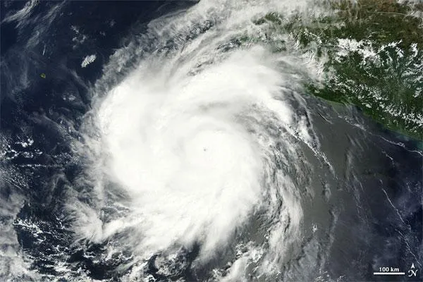
Hurricane Hilary, a Category 3 storm on the Saffir-Simpson scale of hurricane strength, is still spinning off the west coast of Mexico, as seen by NASA's Terra satellite.
Hilary has winds of 120 mph (195 kph) and is moving toward the west, away from the Mexican mainland. At its strongest, Hilary achieved Category 4 status, with winds of 140 mph (220 kph). The storm was still at Category 4 status when the Terra satellite took this image. [See the image here .]
Between tomorrow and early Wednesday, Hilary is expected to slow down and make a turn to the northwest as it weakens.
Latest Videos From
While Hilary's roaring winds and rains are not a threat to land at the moment, it is still generating potentially dangerous rip currents and rough surf along Mexico's coast.
In the Atlantic basin, the only storm currently churning is Tropical Storm Phillipe, which has winds of 60 mph (95 kph). Phillipe is expected to remain a tropical storm over the next few days and is too far out in the ocean to be a threat to any land.
Phillipe is the 16th named storm of the 2011 Atlantic hurricane season, which was forecast to have 14 to 19 named storms (which include tropical storms and hurricanes), seven to 10 hurricanes and three to five major hurricanes (Category 3 or higher). Of the 16 named storms so far this season, three have become hurricanes (Irene, Katia and Maria) and two strengthened to major hurricanes (Irene and Katia).
Follow OurAmazingPlanet for the latest in Earth science and exploration news on Twitter @OAPlanet and on Facebook.