Wildfire Smoke Plume Seen from Space
Get the world’s most fascinating discoveries delivered straight to your inbox.
You are now subscribed
Your newsletter sign-up was successful
Want to add more newsletters?
Delivered Daily
Daily Newsletter
Sign up for the latest discoveries, groundbreaking research and fascinating breakthroughs that impact you and the wider world direct to your inbox.
Once a week
Life's Little Mysteries
Feed your curiosity with an exclusive mystery every week, solved with science and delivered direct to your inbox before it's seen anywhere else.
Once a week
How It Works
Sign up to our free science & technology newsletter for your weekly fix of fascinating articles, quick quizzes, amazing images, and more
Delivered daily
Space.com Newsletter
Breaking space news, the latest updates on rocket launches, skywatching events and more!
Once a month
Watch This Space
Sign up to our monthly entertainment newsletter to keep up with all our coverage of the latest sci-fi and space movies, tv shows, games and books.
Once a week
Night Sky This Week
Discover this week's must-see night sky events, moon phases, and stunning astrophotos. Sign up for our skywatching newsletter and explore the universe with us!
Join the club
Get full access to premium articles, exclusive features and a growing list of member rewards.
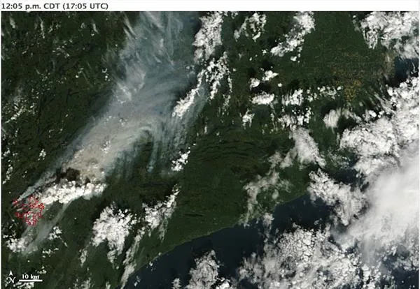
On August 18, 2011, a lightning strike in the Boundary Waters Canoe Area Wilderness region of northeastern Minnesota sparked a forest fire. On September 12, the Incident Information System reported that the Pagami Creek Fire made an unprecedented 16-mile run to the east, reaching the edge of Polly Lake. The fire became a plume-driven event and reached in excess of 60,000 acres.
These natural-color images document the rapid expansion of the fire in just a matter of hours. They also show the development of a plume above the fire. Just after noon, the cauliflower-textured plume rises well above the gray-beige smoke plume that blows toward the north-northeast. Not quite two hours later, the cloudy plume has fanned out to the east and northeast, thick enough to completely hide the land and water surfaces below.
Large fires can do more than scorch vegetation and clog the skies with smoke. They can actually create their own weather. By heating the air overhead, fires push the warmed air upward. Mixed with smoke, the air rises high enough for its water vapor to condense and form clouds. If the air rises fast enough, the water vapor forms ice crystals that charge the cloud with electricity, and lightning often results. These fire-provoked thunderstorm clouds are known as pyrocumulonimbus clouds. Minnesota Public Radio reported that the plume from the Pagami Creek Fire was picked up by doppler radar.
The extreme behavior of the fire prompted evacuations in the region, the Incident Information System reported. More than 100 firefighters were battling the blaze as of September 13, 2011.
- Alaska Volcano Eruption Warning Upgraded
- Remnant of Huge Eruption Smolders On
- Chile Volcano Still Smoking, But Quietly
Get the world’s most fascinating discoveries delivered straight to your inbox.

