 Live Science Plus


You are now subscribed
Your newsletter sign-up was successful
Want to add more newsletters?

Delivered Daily
Daily Newsletter
Sign up for the latest discoveries, groundbreaking research and fascinating breakthroughs that impact you and the wider world direct to your inbox.

Once a week
Life's Little Mysteries
Feed your curiosity with an exclusive mystery every week, solved with science and delivered direct to your inbox before it's seen anywhere else.

Once a week
How It Works
Sign up to our free science & technology newsletter for your weekly fix of fascinating articles, quick quizzes, amazing images, and more

Delivered daily
Space.com Newsletter
Breaking space news, the latest updates on rocket launches, skywatching events and more!

Once a month
Watch This Space
Sign up to our monthly entertainment newsletter to keep up with all our coverage of the latest sci-fi and space movies, tv shows, games and books.

Once a week
Night Sky This Week
Discover this week's must-see night sky events, moon phases, and stunning astrophotos. Sign up for our skywatching newsletter and explore the universe with us!
Join the club
Get full access to premium articles, exclusive features and a growing list of member rewards.
It's aliiiiiiiive! NASA drones flew over Tropical Storm Humberto yesterday (Sept. 16) to study how this "zombie" storm whirled back to life after dissipating over the Atlantic Ocean over the weekend.
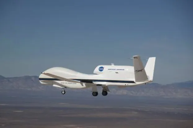
A pair of unmanned Global Hawk aircraft took to the eastern Atlantic skies to peer inside Humberto's mass of clouds and gather data on the storm's environment. The observations will help scientists better understand the storm's life cycle, including the conditions that enabled Humberto to regain strength.
By Sunday (Sept. 15), the remnants of Humberto weakened into a low-pressure area as it passed through a region with strong wind shear, which is caused by differences in atmospheric pressure between neighboring areas. Wind shear typically halts a storm from intensifying by separating its warm core from the surrounding system of circulation. [Image Gallery: Hurricane Season 2013]
But the next day, the wind shear eased up, and Humberto mustered strength and swirled back into a tropical storm. Satellite images confirmed the storm had been reborn, with maximum sustained winds near 40 mph (64 km/h). The storm is expected to simmer over the next couple of days as it moves northwestward in the Atlantic Ocean, according to predictions from the National Hurricane Center.
Humberto is the second "zombie" storm of the season: In early September, Tropical Storm Gabrielle broke up and then regained strength over the western Atlantic Ocean.
NASA's Global Hawks are designed to help researchers observe storms as they develop. The drones can fly continuously for up to 30 hours, and are built to reach altitudes higher than 60,000 feet (18,300 meters), enabling them to fly above tropical storms and hurricanes.
Microwave and radar instruments housed along the plane's underbelly and inside the nose cone gather data on the structure of the storm and the processes happening within it.
NASA's Hurricane and Severe Storm Sentinel (HS3) mission is investigating the factors that lead to hurricane formation and intensification in the Atlantic Ocean. The mission, which will operate until Sept. 23, is also investigating the role of the Saharan Air Layer, a hot, dry and dusty mass of air that may contribute to or inhibit the development of tropical storms.
Follow Denise Chow on Twitter @denisechow. Follow LiveScience @livescience, Facebook & Google+. Original article on LiveScience.

