 Live Science Plus


You are now subscribed
Your newsletter sign-up was successful
Want to add more newsletters?

Delivered Daily
Daily Newsletter
Sign up for the latest discoveries, groundbreaking research and fascinating breakthroughs that impact you and the wider world direct to your inbox.

Once a week
Life's Little Mysteries
Feed your curiosity with an exclusive mystery every week, solved with science and delivered direct to your inbox before it's seen anywhere else.

Once a week
How It Works
Sign up to our free science & technology newsletter for your weekly fix of fascinating articles, quick quizzes, amazing images, and more

Delivered daily
Space.com Newsletter
Breaking space news, the latest updates on rocket launches, skywatching events and more!

Once a month
Watch This Space
Sign up to our monthly entertainment newsletter to keep up with all our coverage of the latest sci-fi and space movies, tv shows, games and books.

Once a week
Night Sky This Week
Discover this week's must-see night sky events, moon phases, and stunning astrophotos. Sign up for our skywatching newsletter and explore the universe with us!
Join the club
Get full access to premium articles, exclusive features and a growing list of member rewards.
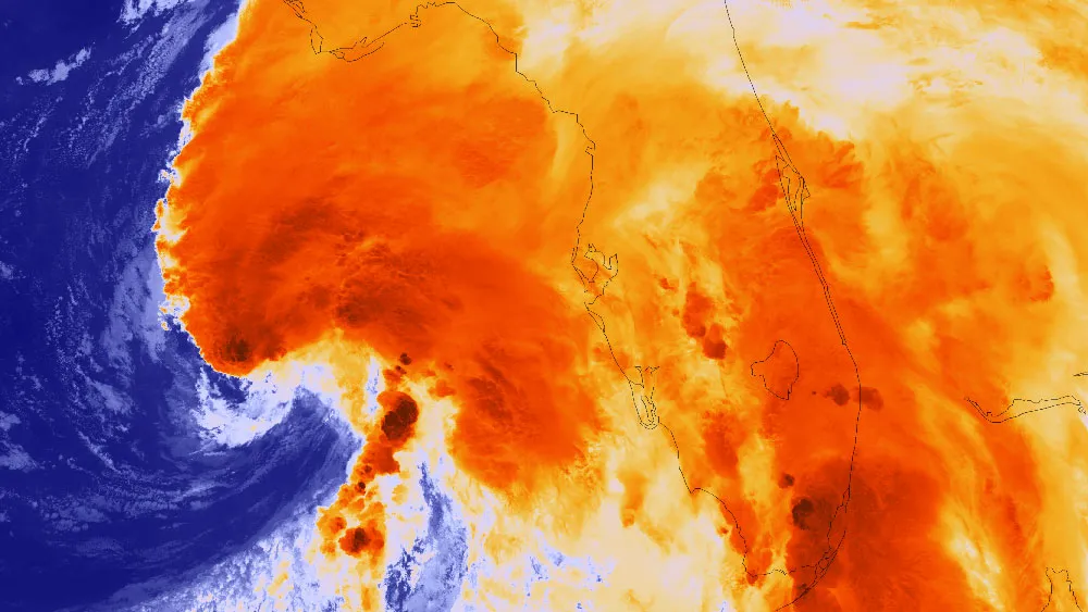
Just a handful of days after the official June 1 start to hurricane season, the first named storm of 2013 has arrived: Tropical Storm Andrea formed yesterday evening (June 5), and is taking aim at Florida.
Forecasters had been watching a low-pressure system in the Gulf of Mexico to see if it would develop into a tropical storm. Yesterday evening, hurricane-hunter aircraft spotted a center of circulation in the system and measured winds that looked to be above the 39-mph (63 km/h) threshold required to qualify as a tropical storm. The storm was given the first name on the 2013 hurricane name list, Andrea.
Since forming, Tropical Storm Andrea has strengthened, becoming larger and developing more intense thunderstorms. As of the most recent National Hurricane Center update on the storm, it has maximum sustained winds of 60 mph (95 km/h). Tropical storm-force winds have been detected 140 miles (220 kilometers) from the storm's center.
The center of the storm is currently 160 miles (255 km) west of Tampa and 140 miles (225 km) south of Apalachicola, Fla., moving to the north-northeast at 14 mph (22 km/h). The storm is expected to make landfall over the Florida peninsula later today; its outer bands are already bringing rains and even tornadoes to Florida.
Andrea had already spawned five tornadoes as of 9 a.m. EDT today (June 6), Weather Underground meteorologist Jeff Masters wrote on his blog. Images of downed trees and power lines from the storm have already emerged online.
The storm is expected to bring rains totaling 3 to 6 inches (7.6 to 15 centimeters) over much of the Florida peninsula, with some areas seeing potentially as much as 10 inches (25 cm) of rain.
After it moves over Florida, Andrea is expected to continue up along the East Coast, from southeast Georgia over Virginia, and possibly into the Northeast.
Andrea is the first of 13 to 20 expected named storms for 2013. Named storms include tropical storms and hurricanes. Seven to 11 of those named storms are expected to become hurricanes. Hurricane season officially ends Nov. 30, though storms have been known to form after that date.
Follow Andrea Thompson @AndreaTOAP, Pinterest and Google+. Follow us @livescience, Facebook & Google+. Original article on LiveScience.com.

