It's quick and easy to access Live Science Plus, simply enter your email below. We'll send you a confirmation and sign you up for our daily newsletter, keeping you up to date with the latest science news.
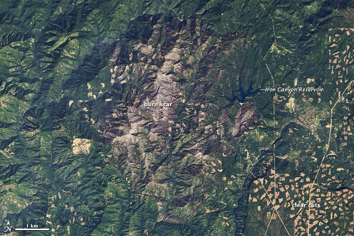
A NASA satellite took this natural color image of the scar left by the Bagley fire near Big Bend, Calif., on Sept. 11. Burned areas appear as bare brown spots of exposed earth.
The Bagley fire, which charred 72 square miles (186 square kilometers) of the Shasta-Trinity National Forest near Big Bend, Calif., this summer, left quite a mark on the landscape.
NASA's Earth Observing-1 (EO-1) satellite took these images — one in natural color and one in false-color — of the scar on Sept. 11. The natural color image shows burned areas as bare brown spots of exposed earth. These appear red in the false-color image. Clear-cutting created the checkered pattern in the forests that can be seen in the lower-right of each image.
The Bagley fire was ignited by lightning on Aug. 18 and grew quickly before being subdued by firefighters, according to Inciweb, a website that provides up-to-date information on wildfires. It is now completely contained, although small smoke-producing fires remain in the interior of the scorched area.
It's been a bad year for wildfires in the United States, partially due to the intense drought gripping much of the country.
The size and frequency of wildfires has increased significantly in the western United States over the last few decades due to climate change and changing forestry practices, according to NASA. Climate change has decreased winter snow cover, quickened the arrival of spring and intensified heat waves in the region — all of which add to fire risk.
Decades of fire suppression have also left denser forests and abundant fuel on the ground that cause fires to spread easily.
There are currently 27 large fires burning across seven states, according to the National Interagency Fire Center. As of today, fires have chewed through 13,094 square miles (33.913 square km). That's above the 10-year average for this date, which is 10,119 square miles (26,207 square km).
Sign up for the Live Science daily newsletter now
Get the world’s most fascinating discoveries delivered straight to your inbox.
A false-color image of the scar left by the Bagley fire near Big Bend, Calif. Red areas show were fire destroyed vegetation.
For the science geek in everyone, Live Science offers a fascinating window into the natural and technological world, delivering comprehensive and compelling news and analysis on everything from dinosaur discoveries, archaeological finds and amazing animals to health, innovation and wearable technology. We aim to empower and inspire our readers with the tools needed to understand the world and appreciate its everyday awe.