Hurricane Dorian a Catastrophic Category 5 Storm. And It's Getting Stronger.
Devastating hurricane conditions are expected in the Bahamas, NASA says.

Get the world’s most fascinating discoveries delivered straight to your inbox.
You are now subscribed
Your newsletter sign-up was successful
Want to add more newsletters?

Delivered Daily
Daily Newsletter
Sign up for the latest discoveries, groundbreaking research and fascinating breakthroughs that impact you and the wider world direct to your inbox.

Once a week
Life's Little Mysteries
Feed your curiosity with an exclusive mystery every week, solved with science and delivered direct to your inbox before it's seen anywhere else.

Once a week
How It Works
Sign up to our free science & technology newsletter for your weekly fix of fascinating articles, quick quizzes, amazing images, and more

Delivered daily
Space.com Newsletter
Breaking space news, the latest updates on rocket launches, skywatching events and more!

Once a month
Watch This Space
Sign up to our monthly entertainment newsletter to keep up with all our coverage of the latest sci-fi and space movies, tv shows, games and books.

Once a week
Night Sky This Week
Discover this week's must-see night sky events, moon phases, and stunning astrophotos. Sign up for our skywatching newsletter and explore the universe with us!
Join the club
Get full access to premium articles, exclusive features and a growing list of member rewards.
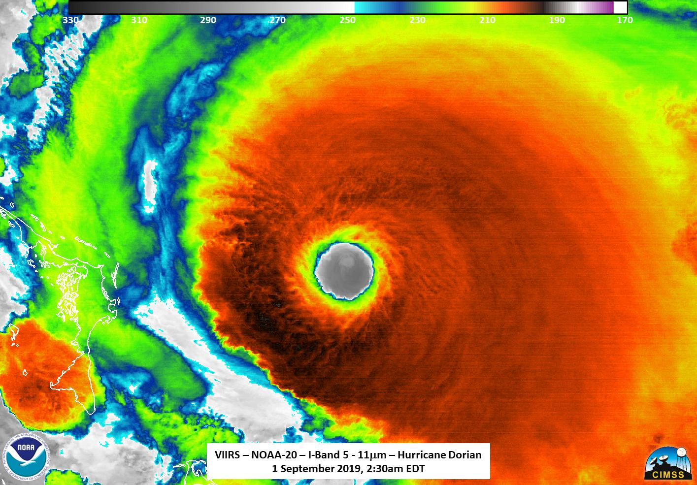
Hurricane Dorian is now a "catastrophic Category 5" storm as it approaches the Bahamas in the Caribbean, according to a National Hurricane Center update today (Sept. 1).
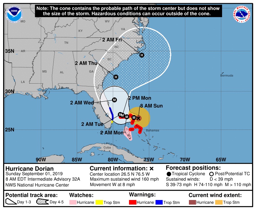
As of 8 a.m. EDT (1200 GMT), Dorian has maximum wind speeds of 160 mph (260 km/h) as the storm churns about 35 miles (55 km) east of Great Abaco Island, the NHC wrote in the update. The storm is about 225 miles (360 km) east of West Palm Beach, Florida.
"Devastating hurricane conditions are expected in the Abacos Islands very soon and these conditions will spread across Grand Bahama Island later today," NASA officials said in an update.
Watch: See Hurricane Dorian in Action in these Gifs from Space
Related: How NASA and NOAA Track Hurricane Dorian from Space
Hurricane Dorian is currently moving west across the Caribbean at about 8 mph (13 km/h), a relatively slow speed that is expected to result in the storm dumping massive amounts of rain on the Abaco Islands. Dorian is expected to slowly move west over the next two days before turning northeast.
"On this track, the core of extremely dangerous Hurricane Dorian should be moving over Great Abaco soon, and continue near or over Grand Bahama Island later tonight and Monday," NHC officials said in the update. "The hurricane should move closer to the Florida east coast late Monday through Tuesday night."
Get the world’s most fascinating discoveries delivered straight to your inbox.
NASA's Kennedy Space Center, in Cape Canaveral, Florida, has taken steps to safeguard itself against Hurricane Dorian. On Friday (Aug. 30), center officials moved a massive 400-foot Mobile Launcher tower into the shelter of the center's 52-story Vehicle Assembly Building to protect it from damage.

NASA, the NHC and the National Oceanic and Atmospheric Administration are using satellites in orbit and U.S. Air Force flights through the eye of Hurricane Dorian itself to track the storm's progress. They've even captured videos of the storm from the International Space Station.
"The NHC has reported that hurricane-force winds extend outward up to 30 miles (45 km) from the center, and tropical-storm-force winds extend outward up to 105 miles (165 km)," NASA officials wrote in its update. "Elbow Cay in the Abaco Islands just reported winds of 35 mph (56 km/h)."
NHC officials warned that Hurricane Dorian's path could change. The storm's eye is currently forecast to remain offshore as the storm moves up the U.S. East Coast from Florida to Georgia, and then on to the Carolinas. Dorian's powerful winds should reach the eastern portions of those states.
- NASA Sees Hurricane Dorian from Space Station (Video)
- NASA's Kennedy Space Center Prepares for Hurricane Dorian
- Photos: Most Powerful Storms of the Solar System
Email Tariq Malik at tmalik@space.com or follow him @tariqjmalik. Follow us on Twitter @Spacedotcom and on Facebook.

Tariq is the editor-in-chief of Live Science's sister site Space.com. He joined the team in 2001 as a staff writer, and later editor, focusing on human spaceflight, exploration and space science. Before joining Space.com, Tariq was a staff reporter for The Los Angeles Times, covering education and city beats in La Habra, Fullerton and Huntington Beach. He is also an Eagle Scout (yes, he has the Space Exploration merit badge) and went to Space Camp four times. He has journalism degrees from the University of Southern California and New York University.
 Live Science Plus


