It's quick and easy to access Live Science Plus, simply enter your email below. We'll send you a confirmation and sign you up for our daily newsletter, keeping you up to date with the latest science news.
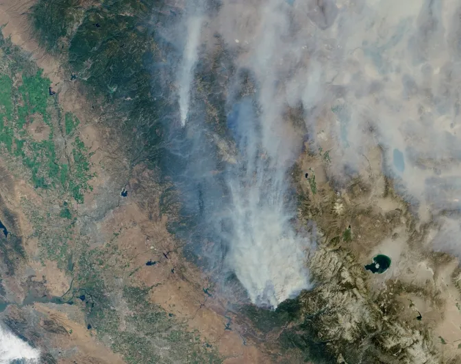
Visible image of California’s Rim Fire acquired Aug. 23, 2013 by the Multi-angle Imaging SpectroRadiometer (MISR) instrument on NASA’s Terra spacecraft, showing extensive, brownish smoke. The imaged area measures 236 by 215 miles (380 by 346 kilometers).
One image taken by the Terra spacecraft's Multi-angle Imaging SpectroRadiometer instrument (MISR) shows smoke rising from the fire that began on Aug. 17 and has burned through nearly 180,000 acres (72,843 hectares) as of Aug. 27, according to NASA officials.
"On the morning of Aug. 23, Terra passed over the fire, allowing MISR’s nadir (vertical-viewing) camera to capture an image of extensive, brownish smoke," NASA officials wrote in a release. "The imaged area measures 236 by 215 miles (380 by 346 kilometers)."
Another photo, captured on Aug. 26 by Aqua's Atmospheric Infrared Sounder (AIRS) instrument shows a plume of carbon monoxide emanating from the California Rim Fire. The image shows a three-day running average of carbon monoxide at an altitude of 3.4 miles (5.5 km) above the planet, NASA officials wrote in a statement.
The plume of carbon monoxide pollution from the Rim Fire burning in and near Yosemite National Park, Calif., is visible in this Aug. 26, 2013 image from the Atmospheric Infrared Sounder (AIRS) instrument on NASA’s Aqua spacecraft.
(Image credit: NASA/JPL-Caltech)
"AIRS is most sensitive to carbon monoxide at this altitude, which is a region conducive to long-range transport of the smoke," NASA officials wrote. "As the carbon monoxide from the fire is lofted into the atmosphere, it becomes caught in the lower bounds of the mid-latitude jet stream, which swiftly transports it around the globe."
As of Aug. 27 the wildfire was 20 percent contained with more than 3,600 personnel battling the blaze. The California Rim Fire is one of 10 major active wildfires burning in California, according to NASA officials. The wildfire has threatened homes, Yosemite National Park, sequoias and the San Francisco water supply.
Sign up for the Live Science daily newsletter now
Get the world’s most fascinating discoveries delivered straight to your inbox.
NASA's Aqua and Terra satellites are prolific Earth-watching observatories. The Aqua satellite launched in 2002, while the Terra satellite launched in 1999.
Miriam Kramer joined Space.com as a staff writer in December 2012. Since then, she has floated in weightlessness on a zero-gravity flight, felt the pull of 4-Gs in a trainer aircraft and watched rockets soar into space from Florida and Virginia. She also serves as Space.com's lead space entertainment reporter, and enjoys all aspects of space news, astronomy and commercial spaceflight. Miriam has also presented space stories during live interviews with Fox News and other TV and radio outlets. She originally hails from Knoxville, Tennessee where she and her family would take trips to dark spots on the outskirts of town to watch meteor showers every year. She loves to travel and one day hopes to see the northern lights in person.

 Live Science Plus