A new global satellite survey of thunderstorm activity has helped meteorologists pinpoint exactly where Earth’s hotspots for intense thunderstorms are: the American Midwest, Argentina , and some semi-arid regions like the edges of the Sahara desert.
The new study, which appeared in the August issue of the Bulletin of the American Meteorological Society, is “really the first quantitative look [at thunderstorms] around the world,” said lead author Edward Zipser of the University of Utah .
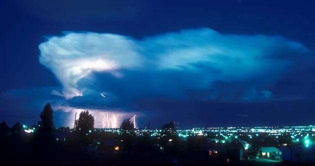
Rockies vs. Andes
Latest Videos From
The strongest storms the satellite observed were in areas east of the Rocky Mountains in the United States and east of the Andes Mountains in Argentina , where geography “is playing a very important part” in storm formation, Zipser said.
In these regions, the mountains help to lift warm, moist air (from the Gulf of Mexico in the U.S. , for example), which collides with cooler, drier air, promoting the formation of powerful storms.
A collision of different types of air masses also forms intense storms in semi-arid regions.
At the edge of the Sahara, for example, very hot, dry air meets with warm, moist air and produces lifting that forms intense storms. When the same phenomenon happens in eastern Colorado , New Mexico and other places in the American Midwest, it can lead to another type of storm. These regions are “essentially the edge of tornado alley," Zipser said.
Though places like the Amazon and parts of Southeast Asia see considerable rainfall, they have few intense thunderstorms because the warm, moist air that covers those regions has no cooler, drier air to mix with.
Puzzling severity
However, certain areas of Central Africa analogous to the Amazon have thunderstorms almost as severe as anywhere on Earth, Zipser said. Meteorologists have no idea what is causing them.
“Quite frankly, everybody’s puzzled,” Zipser said.
To acquire the new global picture of thunderstorm activity, researchers used instruments on the Total Rainfall Measuring Mission (TRMM) satellite to monitor storms all over the Earth from 1998-2004. The TRMM measured different indicators of storm intensity, including the lightning flash rate and the temperature of the storm’s clouds.
The database the study compiled will provide “a new way of challenging and improving our models” by showing if they can accurately predict the observed data, Zipser said. Better models mean that scientists will be able to make better climate predictions and weather forecasts.

 Live Science Plus