Alaska Has Been Mapped as Precisely as Mars

Get the world’s most fascinating discoveries delivered straight to your inbox.
You are now subscribed
Your newsletter sign-up was successful
Want to add more newsletters?

Delivered Daily
Daily Newsletter
Sign up for the latest discoveries, groundbreaking research and fascinating breakthroughs that impact you and the wider world direct to your inbox.

Once a week
Life's Little Mysteries
Feed your curiosity with an exclusive mystery every week, solved with science and delivered direct to your inbox before it's seen anywhere else.

Once a week
How It Works
Sign up to our free science & technology newsletter for your weekly fix of fascinating articles, quick quizzes, amazing images, and more

Delivered daily
Space.com Newsletter
Breaking space news, the latest updates on rocket launches, skywatching events and more!

Once a month
Watch This Space
Sign up to our monthly entertainment newsletter to keep up with all our coverage of the latest sci-fi and space movies, tv shows, games and books.

Once a week
Night Sky This Week
Discover this week's must-see night sky events, moon phases, and stunning astrophotos. Sign up for our skywatching newsletter and explore the universe with us!
Join the club
Get full access to premium articles, exclusive features and a growing list of member rewards.
Alaska is one of the most poorly mapped places on Earth. In fact, topographic maps of Mars and the moon are typically more detailed than those of the Arctic state — until now.
This week, the White House, National Science Foundation and National Geospatial Intelligence Agency (NGA) released the most accurate digital elevation maps of Alaska ever created. After President Barack Obama visited the remote state last year, he passed an executive order to create satellite-based elevation maps of the entire Arctic by 2017, in an effort to track the impact of climate change on the area.
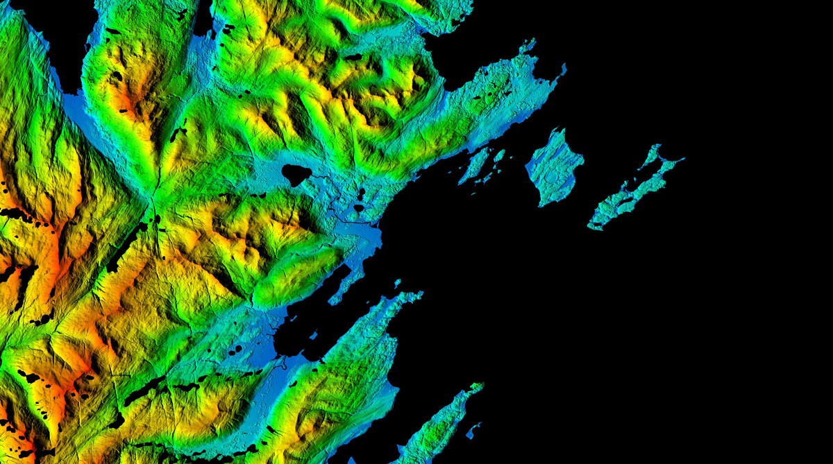
Previous topographical maps of Alaska failed to depict features smaller than 100 feet (30 meters) across. The new maps, however, have a horizontal resolution of around 7 to 17 feet (2 to 5 m) and show elevation differences of smaller than 2 feet (0.6 m). This resolution is sharp enough to reveal the changes caused by a warming climate, according to the researchers. [In Images: Maps of Alaska Help Track Climate Change]
High-resolution digital elevation models (DEMs) are based on stereo pairs of imagery — two images of the same location taken at slightly different times — captured by satellites. An algorithm processes these views into 3D models. It's easier to map the poles this way, because satellites can collect images more frequently across the entire Arctic compared to the traditional method of gathering imagery from an aircraft, which is more expensive and challenging to do, the researchers said. Satellite capabilities allow these new types of maps to be produced regularly, so they can include updates on the changing terrain.
The detailed images of Alaska's terrain can help scientists track sea level change, coastal erosion and melting ice due to climate change.
"The Arctic region is experiencing some of the most rapid and profound changes in the world," Ambassador Mark Brzezinski, executive director of the Arctic Executive Steering Committee at the White House, said in a statement. "These changes impact communities, as well as the ecosystems upon which they depend. Yet, much of Alaska and the Arctic lacks even basic modern and reliable maps to help Arctic communities understand and manage these risks. The DEMs will address this gap."
By serving as a benchmark for the state's topography, the maps will allow scientists to observe patterns of erosion, melting and other natural processes over time, the National Science Foundation said. By better understanding these changes, the government can develop more effective strategies to combat climate change, NGA Director Robert Cardillo said.
Get the world’s most fascinating discoveries delivered straight to your inbox.
"The models will play an important role in informing policy and national security decisions," Cardillo said. "They may also provide critical data and context for decisions related to climate resilience, land management, sustainable development, safe recreation and scientific research."
Data from the Arctic DEM mission is freely accessible on the NGA website and through a web-based viewer.
Original article on Live Science.

 Live Science Plus


