 Live Science Plus


You are now subscribed
Your newsletter sign-up was successful
Want to add more newsletters?

Delivered Daily
Daily Newsletter
Sign up for the latest discoveries, groundbreaking research and fascinating breakthroughs that impact you and the wider world direct to your inbox.

Once a week
Life's Little Mysteries
Feed your curiosity with an exclusive mystery every week, solved with science and delivered direct to your inbox before it's seen anywhere else.

Once a week
How It Works
Sign up to our free science & technology newsletter for your weekly fix of fascinating articles, quick quizzes, amazing images, and more

Delivered daily
Space.com Newsletter
Breaking space news, the latest updates on rocket launches, skywatching events and more!

Once a month
Watch This Space
Sign up to our monthly entertainment newsletter to keep up with all our coverage of the latest sci-fi and space movies, tv shows, games and books.

Once a week
Night Sky This Week
Discover this week's must-see night sky events, moon phases, and stunning astrophotos. Sign up for our skywatching newsletter and explore the universe with us!
Join the club
Get full access to premium articles, exclusive features and a growing list of member rewards.
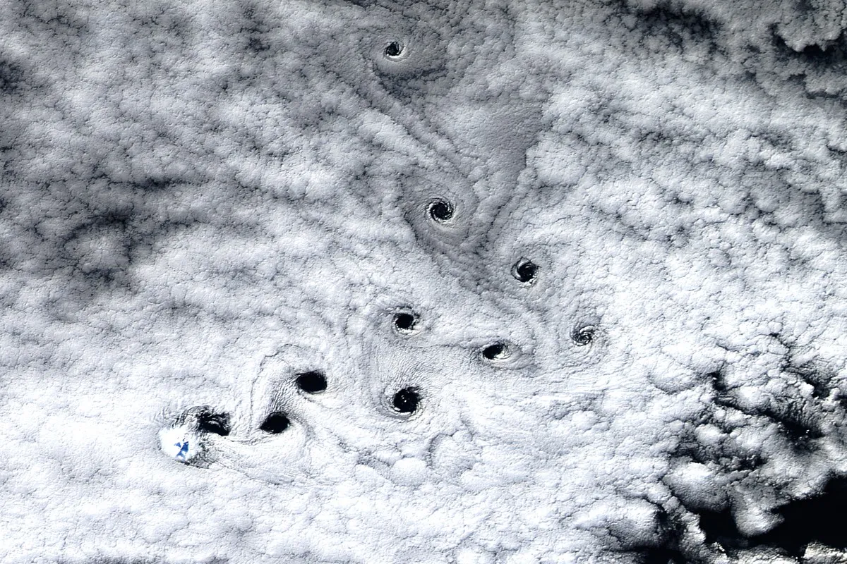
Whimsical cloud vortices dot the sky in a new satellite image of an island volcano.
The shot, captured by the Operational Land Imager on the Landsat 8 satellite, shows eddies in the air near Mawson Peak on Heard Island. The island is in the Indian Ocean and belongs to Australia. At 9,006 feet (2,745 meters), Mawson Peak is the island's highest point, according to NASA's Earth Observatory, which released the image May 8. [See Images of Some of the Weirdest Clouds]
Heard Island is off the beaten path, to say the least. It's nearly 2,500 miles (4,000 kilometers) from Australia and more than 600 miles (1,000 km) from Antarctica. But wildlife finds refuge on Heard Island and the islands that surround it. According to the Australian government, four penguin species make their home in the island group, living alongside 15 species of breeding birds, including albatross and petrol. Southern elephant seals, Antarctic fur seals and subantarctic fur seals also use the islands as breeding grounds.
Heard Island is about 24 miles (40 km) long, and growing: Fresh lava has been flowing from Big Ben, the volcano whose highest peak is Mount Mawson, since at least the 1980s. What isn't dominated by fire is covered in ice: According to the Australian government, 70 percent of Heard Island is permanently glaciated.
None of that is visible under the cloud cover in the new image, which was taken May 3. What is visible are the disrupted air patterns caused by Mawson Peak. The clear circles are called von Kármán vortices after the physicist who first described them.

It's not the first time satellite imagery has revealed such patterns. In 2012, NASA released a shot of Saint Helena, a volcanic island in the South Atlantic Ocean, featuring similar vortices. They also appear in a shot of Guadalupe in the Pacific taken that same year.
Heard Island is in the "Furious 50s," latitudes known for their strong westerly winds. In short, according to the Australian government, the island is cold, cloudy, wet and windy. Vortices aren't the only cloud formations seen downwind of Big Ben's peaks, either. Cap clouds, which are dome-shaped cloud formations, are sometimes seen hovering over the tops of mountains. UFO-shaped lenticular clouds and twirling roll or rotor clouds (so named because they seem to roll along a horizontal axis, like a barrel down a hill) also form in the turbulent atmosphere above the island.
Follow Stephanie Pappas on Twitter and Google+. Follow us @livescience, Facebook& Google+. Original article on Live Science.

