


Amazing Images of Pakistan's Earthquake Island

Pakistan's earthquake island

A new island, now called Zalzala Koh, emerged offshore of the town of Gwadar in Pakistan after a powerful Sept. 24 earthquake. Likely a form of mud volcano, the island rose from the seafloor hours after the magnitude-7.7 earthquake struck about 380 kilometers (230 miles) inland.
Birth of an island

On Sept. 26, 2013, the Advanced Land Imager on NASA's Earth Observing-1 satellite captured an image of Pakistan's new island, which sits roughly one kilometer (0.6 miles) offshore of the town of Gwadar.
Before the earthquake

No island is visible in this image of Gwadar from April 17, 2013, snapped by the Landsat 8 satellite.

Zalzala Koh close-up
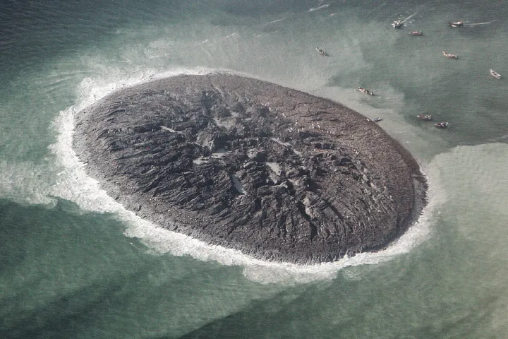
An aerial photo from Pakistan's National Institute of Oceanography suggests the gray-colored mound is about 60 to 70 feet (15 to 20 meters) tall. The surface is covered in sea creatures such as dead fish and is a mixture of mud, sand and rock. It is solid enough for people to walk on.
How big?

The French Pleiades satellite mapped the muddy hill's dimensions, which measure 576.4 feet (175.7 meters) long by 524.9 feet (160 m) wide. Similar islands appeared offshore of Pakistan after earthquakes in 1945 and 2001.
Get the world’s most fascinating discoveries delivered straight to your inbox.
