El Niño: Facts, news, features and articles about the climate cycle that impacts weather patterns around the globe
What is El Niño?
El Niño is a climate cycle in the Pacific Ocean that impacts weather patterns around the world.
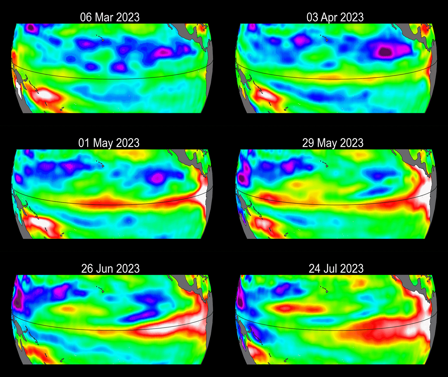
The cycle begins when warm water in the western tropical Pacific Ocean shifts eastward along the equator toward the coast of South America. Normally, this warm water pools near Indonesia and the Philippines, but during El Niño, the Pacific's warmest surface waters sit offshore of northwestern South America.
Tropical storms also occur in more eastward locations during El Niño because atmospheric moisture is fuel for thunderstorms, and the greatest amount of evaporation takes place above the ocean's warmest water.
The opposite of El Niño is La Niña, which is when the waters of the tropical eastern Pacific are colder than normal and trade winds blow more strongly than usual.
Collectively, El Niño and La Niña are parts of an oscillation in the ocean-atmosphere system called the El Niño-Southern Oscillation, or ENSO cycle, which also has a neutral phase.
How long does El Niño last?
El Niño conditions occur every three to five years but may come as frequently as every two years or as rarely as every seven years. Typically, El Niño events occur more frequently than La Niña conditions. Each event usually lasts nine to 12 months. They often begin to form in spring, reach peak strength between December and January, and then decay by May of the following year.
What causes El Niño?
Scientists still don't fully understand what triggers an El Niño cycle. Not all El Niño events are the same, nor do the atmosphere and ocean always follow the same patterns from one El Niño to another.
To forecast El Niño, scientists monitor several regions across the Pacific.
"You have to think of each region as an ocean sloshing around," said Neville Sweijd, director of the Alliance for Collaboration on Climate and Earth Systems Science (ACCESS) in South Africa. "Sometimes it sloshes to one side, and sometimes it sloshes to the other. That's El Niño and La Niña."
Experts "monitor the average sea-surface temperature in each region and use that to form a model," he told Live Science. "The models will then predict the likelihood of the manifestation."
In normal, non-El Niño conditions, trade winds blow toward the west across the tropical Pacific, away from South America. These winds pile up warm surface water in the western Pacific so that the sea surface is about 1.5 feet (0.5 meters) higher near Indonesia than it is off the shore of Ecuador. Higher sea-surface temperatures cause water levels to expand and rise and also shift rainfall from the land to the ocean.
In a non-El Niño year, the sea-surface temperature is also about 14 degrees Fahrenheit (8 degrees Celsius) warmer in the western Pacific. Cooler ocean temperatures dominate off the coast of northwest South America, due to an upwelling of cold water from deeper levels.
Forecasters declare an official El Niño when they see both ocean temperatures and rainfall from storms veer to the east. Experts also look for prevailing trade winds to weaken. These changes set up a feedback loop between the atmosphere and the ocean that boosts El Niño conditions.
Does El Niño cause more rain, or drought?
During El Niño, the trade winds weaken in the central and western Pacific. Surface water off South America warms up because there is less upwelling of the cold water from below to cool the surface. The clouds and rainstorms associated with warm ocean waters also shift eastward. The warm waters release so much energy into the atmosphere that weather changes all over the planet.
El Niño creates stronger wind shear and more stable air over the Atlantic, which makes it harder for hurricanes to form there. However, the warmer-than-average ocean temperatures boost eastern Pacific hurricanes, contributing to more active tropical storm seasons.
Strong El Niño events are also associated with above-average precipitation in the southern United States. The cloudier weather typically causes below-average winter temperatures in that part of the country, while temperatures tilt warmer than average in northern U.S. states. Rainfall is often below average in the Ohio and Tennessee valleys and the Pacific Northwest during El Niño, according to NOAA.
Record rainfall often strikes Peru, Chile and Ecuador during El Niño.
El Niño also affects precipitation in other areas, including Indonesia and northeastern South America, which tend toward drier-than-normal conditions. Temperatures in Australia and Southeast Asia run hotter than average. El Niño-caused drought can be widespread, affecting southern Africa, India, Southeast Asia, Australia, the Pacific Islands and the Canadian prairies.
Unlike El Niño, La Niña events are characterized by a sustained cooling effect around the equator and eastern tropical Pacific. This often results in stronger and more frequent hurricanes across North America and can lead to heavy flooding in many Pacific Island nations, as well as droughts along the west coast of South America.

Aimee Gabay is an independent journalist based in London, U.K. Focusing on land rights, nature and climate change, her reporting has appeared in Al Jazeera, Mongabay and New Scientist.
Latest about el nino

Live Science Today: Super El Niño looms and Starlink hits 10,000 satellites in orbit
By Ben Turner published
Daily Roundup Tuesday, March 17, 2026: Your daily shot of the biggest science stories making headlines.
'Super El Niño' could push global temperatures to unprecedented highs, forecasters say
By Patrick Pester published
A "super El Niño" could emerge by the end of the 2026 hurricane season, with forecasters predicting that the ongoing La Niña is about to finish.
Critical moment when El Niño started to erode Russia's Arctic sea ice discovered
By Skyler Ware published
Scientists discover a tipping point that took place in 2000, where El Niño’s effect on sea ice loss in Siberia was amplified.
Forecasters predict La Niña conditions this fall: What to expect
By Patrick Pester published
NOAA forecasts suggest we could experience La Niña conditions in the fall and early winter. However, this potential La Niña spell is unlikely to break records.

96% of oceans worldwide experienced extreme heatwaves in 2023, new study finds
By Perri Thaler published
The extreme marine heatwaves of 2023 may signal a tipping point for Earth's climate, a new study suggests.
La Niña is dead — what that means for this year's hurricanes and weather
By Evan Howell published
Scientists thought La Niña was coming. It didn't — at least for now. What could that mean for this year's hurricane season, and how might long-term climate change affect El Niño and La Niña patterns?

1,200-year-old remains of dismembered pregnant woman in Ecuador hint at 'enigmatic' sacrifice to thwart El Niño
By Kristina Killgrove published
The unusual burial of a woman and fetus in prehistoric Ecuador may reflect the community's fear of her power.
'Unusual' and weak La Niña finally here, NOAA confirms
By Patrick Pester published
NOAA has declared that a La Niña is underway. This cool weather event is likely to be shorter and weaker than usual, but will still affect global weather and climate.

Climate change is the worst. Here's just how bad it got this year.
By Hannah Osborne published
The big news in Earth science this year was all about climate change, with extreme weather, flooding and drought attributed to warming. Scientists also warned about much worse to come if we don't rein in carbon emissions.
Get the world’s most fascinating discoveries delivered straight to your inbox.
 Live Science Plus


