
 Live Science Plus


Current La Niña Could be Strongest Ever Recorded

This year's La Niña event, a cyclical cooling of the Pacific Ocean, could be one for the record books, according to new satellite data from NASA.
Satellite images of the Pacific Ocean reveal La Niña stayed strong in the final two months of 2010.
"The solid record of La Niña strength only goes back about 50 years and this latest event appears to be one of the strongest ones over this time period," said Bill Patzert, a climatologist at NASA's Jet Propulsion Laboratory in Pasadena, Calif.

Patzert said this powerful La Niña's effects can be felt around the world, and researchers say it is partially responsible for the floods now devastating Australia.
"The copious rainfall is a direct result of La Niña’s effect on the Pacific trade winds and has made tropical Australia particularly rainy this year," said David Adamec, an oceanographer at NASA's Goddard Space Flight Center, in Greenbelt, Md.
"Although exacerbated by precipitation from a tropical cyclone, rainfalls of historic proportion in eastern Queensland, Australia have led to levels of flooding usually only seen once in a century," Adamec said.
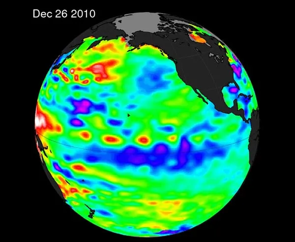
The new NASA satellite image depicts sea surface height, which is linked to sea temperature as water expands when it heats up and becomes more compact as it cools. The cooler-than-normal pool of water that stretches from the eastern to the central Pacific Ocean is a hallmark of a La Niña event.
"This La Niña has strengthened for the past seven months, and is one of the most intense events of the past half century," Patzert said.
This article was provided by OurAmazingPlanet, a sister site to LiveScience.
