Why does Mars look purple, yellow and orange in ESA's stunning new satellite image?
Surprising colors and stunning features are captured in a new image of Mars' surface.

Get the world’s most fascinating discoveries delivered straight to your inbox.
You are now subscribed
Your newsletter sign-up was successful
Want to add more newsletters?

Delivered Daily
Daily Newsletter
Sign up for the latest discoveries, groundbreaking research and fascinating breakthroughs that impact you and the wider world direct to your inbox.

Once a week
Life's Little Mysteries
Feed your curiosity with an exclusive mystery every week, solved with science and delivered direct to your inbox before it's seen anywhere else.

Once a week
How It Works
Sign up to our free science & technology newsletter for your weekly fix of fascinating articles, quick quizzes, amazing images, and more

Delivered daily
Space.com Newsletter
Breaking space news, the latest updates on rocket launches, skywatching events and more!

Once a month
Watch This Space
Sign up to our monthly entertainment newsletter to keep up with all our coverage of the latest sci-fi and space movies, tv shows, games and books.

Once a week
Night Sky This Week
Discover this week's must-see night sky events, moon phases, and stunning astrophotos. Sign up for our skywatching newsletter and explore the universe with us!
Join the club
Get full access to premium articles, exclusive features and a growing list of member rewards.
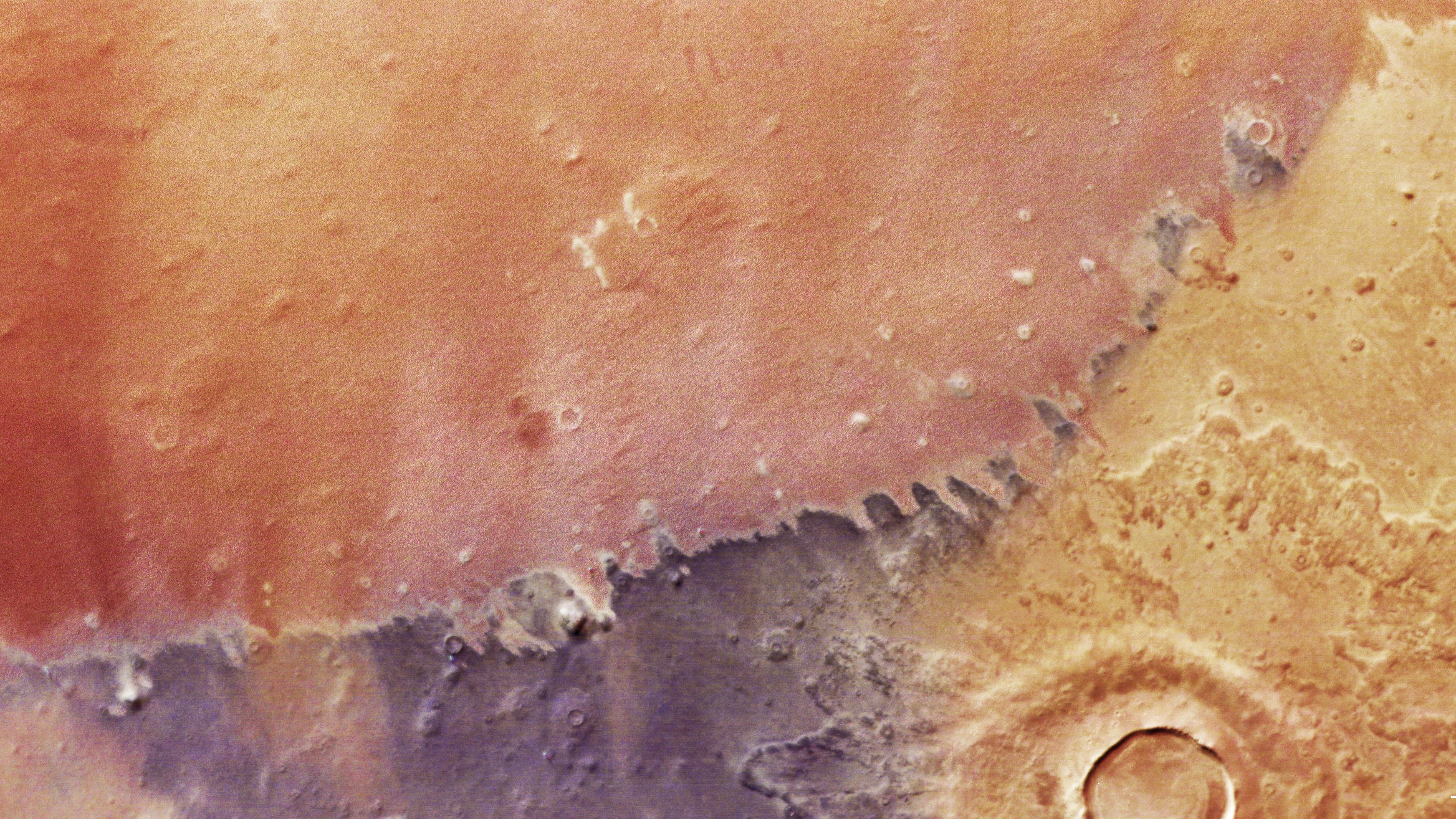
Despite being known as the Red Planet, Mars shows off its swirling yellows, oranges and browns in a new satellite photo from the European Space Agency (ESA). The Earth-toned surface also reveals an impact crater and four sneaky dust devils making their way across the region.
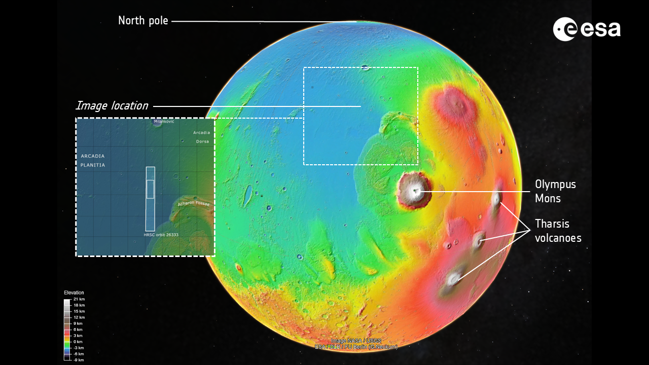
The Rothko-like image was taken by a high-resolution camera on ESA’s Mars Express orbiter and captures Arcadia Planitia, an area of Mars critical to research about the planet’s past and its potential to house humans in the future.
Arcadia Planitia
Northwest of the tallest volcanoes in the solar system, Arcadia Planitia is a region of intrigue. It's laden with solidified lava flows that are, at most, 3 billion years old. The area is also thought to host water ice close to the planet's surface, making it an area of interest when planning future missions to Mars, according to a statement from ESA.

Arcadia Planitia is home to visiting "dust devils," short-lived columns of wind akin to small tornadoes. Dust devils form when the Martian surface warms the air just above it, leading the air to rise and pulling dust with it. The new image shows four dust devils as they snake their way across the plains of the region. Easy to overlook, you can spot them as whitish puffs of dust near the center of the image, straddling the boundary between the darker brown and lighter red parts of the plain.
A large impact crater sits in the bottom right corner of the photo and measures 9 miles (15 kilometers) across, according to ESA. The formation of layered material around the crater is evidence that the ground encompassed notable amounts of water ice during impact, and lack of clear erosion of the crater dates it to relatively recently on the geological timeline.
Is the picture out of focus?
If you noticed that the image is blurry, you're discerning an effect of the wind on Mars. Gusts of air pick up and carry tiny particles of debris from the planet's surface, which creates a minor visual haze.
Get the world’s most fascinating discoveries delivered straight to your inbox.
The wind that causes the haze is also responsible for the reddish area at the top of the photo. The red region is covered in ridges called "yardangs," which are formed when wind erodes vulnerable rock and leaves the most resistant rock still standing.
Below the red section is purplish-brown terrain, which has a high concentration of silicates and a low concentration of iron, the statement notes. The difference in colors also stems from properties of the sand, like density and size, which affect how the grains accumulate and travel across Mars.
Mars quiz: Is your knowledge of the Red Planet out of this world?

Perri Thaler is an intern at Live Science. Her beats include space, tech and the physical sciences, but she also enjoys digging into other topics, like renewable energy and climate change. Perri studied astronomy and economics at Cornell University before working in policy and tech at NASA, and then researching paleomagnetism at Harvard University. She's now working toward a master's degree in journalism at New York University and her work has appeared on ScienceLine, Space.com and Eos.
You must confirm your public display name before commenting
Please logout and then login again, you will then be prompted to enter your display name.
 Live Science Plus


