It's quick and easy to access Live Science Plus, simply enter your email below. We'll send you a confirmation and sign you up for our daily newsletter, keeping you up to date with the latest science news.
Earth's mysterious eighth continent doesn't appear on most conventional maps; that's because almost 95% of its land mass is submerged thousands of feet beneath the Pacific Ocean.
Zealandia — or Te Riu-a-Māui, as it's referred to in the indigenous Māori language — is a 2 million-square-mile (5 million square kilometers) continent east of Australia, beneath modern-day New Zealand. Scientists discovered the sprawling underwater mass in the 1990s, then gave it formal continent status in 2017. Still, the "lost continent" remains largely unknown and poorly studied due to its Atlantean geography.
Now, GNS Science — a geohazards research and consultancy organization owned by the government of New Zealand — hopes to raise Zealandia (in public awareness, at least) with a suite ofnew maps and interactive tools that capture the lost continent in unprecedented detail.
"We've made these maps to provide an accurate, complete and up-to-date picture of the geology of the New Zealand and southwest Pacific area — better than we have had before," Nick Mortimer, a geologist and lead author of the maps,said in a statement. "Their value is that they provide a fresh context in which to explain and understand the setting of New Zealand's volcanoes, plate boundary and sedimentary basins."
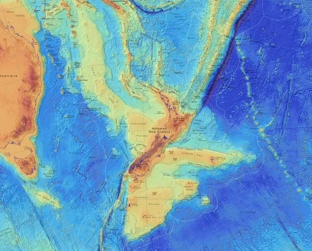
A tectonic map showing the age and type of rock beneath Zealandia.
(Image credit: GNS Science)
The new maps reveal Zealandia's bathymetry (the shape of the ocean floor) as well as its tectonic history, showing how volcanism and tectonic motion haveshaped the continent over millions of years. Data for the bathymetric map was provided by the Seabed2030 project — a global effort to map the entire ocean floor by 2030. (The project isabout 20% complete.)
The team also released interactive versions of both maps on a newZealandia webpage. Spend a few minutes clicking around the hyper-detailed images — and, when someone asks what you're doing, simply tell them you're "discovering Earth's lost continent."
Sign up for the Live Science daily newsletter now
Get the world’s most fascinating discoveries delivered straight to your inbox.
For a limited time, you can take out a digital subscription to any of our best-selling science magazines for just $2.38 per month, or 45% off the standard price for the first three months.
Brandon is the space / physics editor at Live Science. With more than 20 years of editorial experience, his writing has appeared in The Washington Post, Reader's Digest, CBS.com, the Richard Dawkins Foundation website and other outlets. He holds a bachelor's degree in creative writing from the University of Arizona, with minors in journalism and media arts. His interests include black holes, asteroids and comets, and the search for extraterrestrial life.

 Live Science Plus