Nipping at the heels of the monster storm Irma, which battered several Caribbean islands last night, two other named storms are brewing.
Tropical storm Jose is swirling in the Atlantic, while tropical storm Katia is growing in the southern Gulf of Mexico.
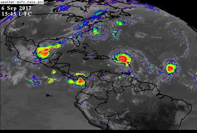
As of 5 a.m. ET today (Sept. 6), Jose had sustained wind speeds of 60 mph (97 km/h) and was moving west at 13 mph (21 km/h), about 1,250 miles (2,011 kilometers) from the Lesser Antilles, according to the National Hurricane Center (NHC). Jose is expected to strengthen into a hurricane later tonight, with maximum sustained wind speeds of about 110 mph (177 km/h) in the next few days, before slowing down and heading north sometime over the weekend. It's too soon to say if it will hit the United States, but the current forecast suggests that is unlikely. The current forecast track has the storm curving north and missing the United States entirely, according to the NHC. [Hurricane Irma Photos: Images of a Monster Storm]
Latest Videos From
As of 4 a.m. CT today, tropical storm Katia had sustained winds of about 40 mph (64 km/h) and was hovering about 105 miles (169 km) east of Tampico, Mexico. It was slowly meandering south at about 2 mph (3 km/h). The storm is likely to hit Mexico sometime over the weekend, according to the NHC's latest forecast.
As predicted by the most recent hurricane forecast, conditions this year have fueled an unusually active hurricane season. The lack of an El Niño, a weather phenomenon in which warm waters from the western Pacific Ocean shift to the central, eastern and tropical Pacific, means big storms are allowed to grow. Essentially, El Niño's absence means less wind shear and weaker trade winds in the Atlantic Ocean that can break up storms before they gain strength.
That, coupled with the warmer-than-usual waters in the Atlantic Ocean, have created the perfect nursery for baby storms to grow into big ones. The most recent hurricane outlook predicted between 14 and 19 named storms, or those with sustained wind speeds of at least 39 mph (62 km/h), and between two and five major hurricanes, with sustained wind speeds of at least 111 mph (178 km/h). Already, this season has seen 11 named storms and four hurricanes (Franklin, Gert, Harvey and Irma), with Jose likely to strengthen into a hurricane later tonight. Hurricane season typically lasts until Nov. 30, though the peak of activity is generally between August and September, with Sept. 10 being the most active day of the year, on average.
Originally published on Live Science.

 Live Science Plus