A new island suddenly emerged from the sea just off the coast of North Carolina — but officials warn that the spit of land is too dangerous for humans to explore.
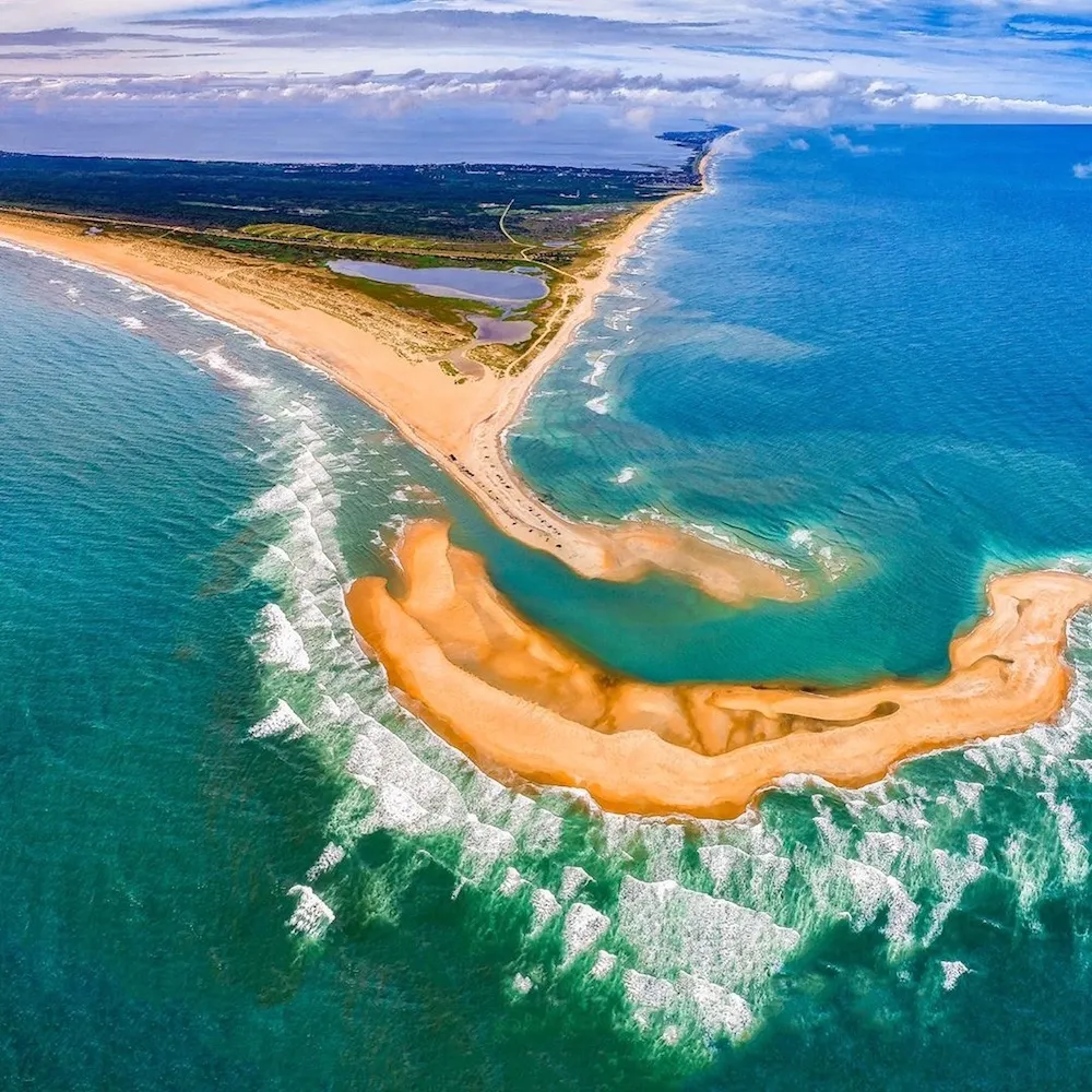
The new sandbar island seemingly sprang from the ocean in just a few weeks, the Virginian Pilot reported. The island, which is about 1 mile (1.6 kilometers) long and about 480 feet (146 meters) wide, lies off the coast of Buxton, North Carolina, which is part of the Cape Hatteras National Seashore.
The new island grew from a mere nubbin in the ocean in April to its current size over Memorial Day weekend. One of the early explorers of the island, Janet Regan, took her 11-year-old son there to collect seashells. Because of its treasure trove of shells, the boy named it Shelly Island, the Pilot reported. [See Images of a Volcanic Island Birthed in Japan]
Latest Videos From
Close but dangerous
While the newborn island may be tantalizing for would-be explorers, it's also very dangerous, Bill Smith, president of the North Carolina Beach Buggy Association, told the Pilot. Officials with the Cape Hatteras National Seashore have warned people not to try to reach the island.
Because the island formed near a popular fishing spot, years' worth of fishing hooks could be lurking just below the sand. Sharks and stingrays prowl just beneath the water's surface in the area, and the narrow 50-foot (15 m) strip of water between the island and the mainland forms a little "river" that creates a strong rip current, he said.
"We're worried about shark bites, but we're more worried about drownings," Smith said.
The sandbar isn't accessible by foot, so photographer Chad Koczera sent a drone into the skies to capture a stunning aerial photo. More intrepid (or foolhardy) explorers also have tried to reach the island by boat or paddleboard, the Pilot reported.
The area of coastline near the island is always transforming, according to a statement from the Cape Hatteras National Seashore. The point, called Cape Point, sometimes changes orientation, and currents and storms are constantly shaping the land. It's likely that such forces formed the sandbar, meaning it could get even bigger or sink beneath the waves in the next year or two, Smith said.
If anyone does attempt a trip to the island, National Seashore Superintendent David Hallac said such a trip "is best accomplished by experienced kayakers or paddle boarders that are using appropriate flotation and mindful of the tides and strong currents in the area."
Originally published on Live Science

 Live Science Plus