 Live Science Plus


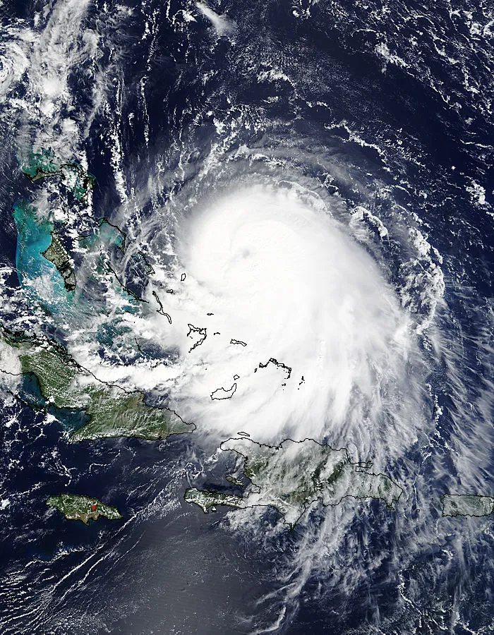
As Hurricane Joaquin strengthens over the Bahamas, forecasters are split on how badly the storm could batter the U.S. East Coast, if it even makes landfall at all.
"We don't know what is actually going to be felt from Joaquin. It's too early — it's still sitting in the middle of the Bahamas," said Dennis Feltgen, a spokesman for the National Hurricane Center in Miami.
Part of this uncertainty is because Hurricane Joaquin is still at least three days away from making landfall, and hurricane watches, which determine that hazardous weather in a region is possible, are typically issued only about 48 hours in advance, Feltgen said. [Hurricanes from Above: See Images of Nature's Biggest Storms]
Article continues belowBut more forecasters are beginning to think Hurricane Joaquin will bypass the East Coast entirely, said Joseph D'Aleo, the chief meteorologist at WeatherBell Analytics, a meteorological consulting firm headquartered in New York City.
Either way, people in the Carolinas should prepare for flooding and get out their umbrellas and raincoats, because they can expect heavy rain from a different weather pattern, D'Aleo told Live Science.
Too early to tell?
Right now, the tropical storm is gathering force as it batters the Bahamas. The storm has produced maximum wind speeds of 125 miles per hour (200 km/h), according to the National Hurricane Center in Miami.
"Joaquin is expected to intensify a little more in the next 12 to 24 hours as it remains over very warm waters and in an environment of decreasing vertical shear," or a decrease in the difference in wind speeds with height in the atmosphere, according to a forecast discussion issued by the National Hurricane Center.
After that, Hurricane Joaquin will probably head northwest, and then north, meteorologists say. But the models get muddled when projecting the storm's path more than 36 hours from now. American models have the hurricane veering northwest and making landfall over the Carolinas and the mid-Atlantic. Other models show Joaquin heading east and battering Bermuda before dissipating over the Atlantic Ocean, according to the National Hurricane Center.
The weather models are also diverging when predicting Joaquin's strength. Some forecasts predict the storm will weaken in the next 24 hours, while others suggest it will strengthen, according to the National Hurricane Center.
In this instance, there's more uncertainty about Hurricane Joaquin because "there's a very complex weather pattern surrounding Joaquin that could have a big influence on where it goes," Feltgen told Live Science.
A high-pressure ridge in the upper atmosphere is flanking Hurricane Joaquin to the north, while a low-pressure system covers the Eastern and Southeastern United States. Combined, these two weather patterns create a lot of uncertainty in mapping the storm's potential track, Feltgen said.
Models converging
Initially, European models suggested the tropical storm would miss the U.S. coast altogether, while American models showed the storm heading for the Carolinas and even New York City, D'Aleo said. (The same European model was the first to predict that Hurricane Sandy would tack west and batter New Jersey, while the American models took longer to predict that shift, he added.)
Overnight, the models began to converge.
"It looks right now like Joaquin will — after it vacations in the Bahamas for another day — will turn north and then northeast and head out to sea and not affect the mainland at all," D'Aleo said.
A large, counterclockwise swirling vortex of air in the atmosphere southeast of the United States will likely play a large role in where Hurricane Joaquin will go, D'Aleo said.
American models predicted that Joaquin would shift northward and be pushed northwest. But, because Joaquin has drifted farther southwest than those models forecasted, that same swirling vortex will slingshot it east rather than west, he said.
But even if most of the U.S. East Coast is spared Hurricane Joaquin's worst effects, South Carolina should brace for heavy rainfall, he said. That's because a cool front laden with moisture is heading south on the East Coast. That region could expect between 8 and 20 inches (20 to 51 cm) of rainfall in some locales, he said.
"The only people that will see any severe weather will be the Carolinas, but it really isn't related to Joaquin," D'Aleo said.
Follow Tia Ghose on Twitter and Google+. Follow Live Science @livescience, Facebook & Google+. Original article on Live Science.

