














Hurricane Henriette Features 10-Mile-High Thunderstorms

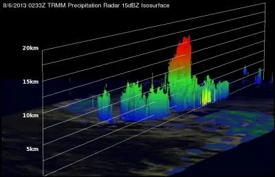
Hurricane Henriette, churning across the Pacific as a Category 2 storm, was spotted by NASA's Tropical Rainfall Measuring Mission (TRMM) satellite on Aug. 6, with thunderstorms whose tops extended 10 miles (16 kilometers) up in the atmosphere.
Henriette first formed as a tropical depression in the Eastern Pacific on Aug. 3, just behind Tropical Storm Gil. As Gil faded, Henriette strengthened into a tropical storm, then a hurricane. While it has reached Category 2 status, it is expected to weaken soon, according to the latest forecasts from the National Hurricane Center in Miami.
The hurricane's 10-mile-high thunderstorm clouds aren't unexpected for a strong storm — the stronger the storm, the higher its clouds reach in the atmosphere. These high clouds tend to be the ones that drop the most rainfall during a storm. TRMM measured the rainfall rate from thunderstorms near Henriette's center to be about 2.2 inches (5.5 centimeters) per hour.
The TRMM team at NASA's Goddard Space Flight Center in Greenbelt, Md., used the data the satellite took to create 3D images of the storm that clearly show the tall thunderclouds, which are known as "hot towers," because of the intense latent heat released by the storms as water condenses in them.
Henriette isn't expected to be a threat to land, as it is far out at sea, about 1,100 miles (1,780 kilometers) east of Hilo, Hawaii, and moving westward.
While the Eastern Pacific has seen much storm activity over the last few weeks, the Atlantic basin has been quiet. The busiest part of the Atlantic hurricane season is typically mid-August through September. The next storm to form in the Atlantic will be named Erin.
Follow Andrea Thompson @AndreaTOAP, Pinterest and Google+. Follow OurAmazingPlanet @OAPlanet, Facebook and Google+. Original article at LiveScience's OurAmazingPlanet.
Get the world’s most fascinating discoveries delivered straight to your inbox.

Andrea Thompson is an associate editor at Scientific American, where she covers sustainability, energy and the environment. Prior to that, she was a senior writer covering climate science at Climate Central and a reporter and editor at Live Science, where she primarily covered Earth science and the environment. She holds a graduate degree in science health and environmental reporting from New York University, as well as a bachelor of science and and masters of science in atmospheric chemistry from the Georgia Institute of Technology.