An instrument aboard a NASA satellite has allowed forecasters to take a peek beneath Hurricane Irene's roiling clouds to see how much rain the storm is making.
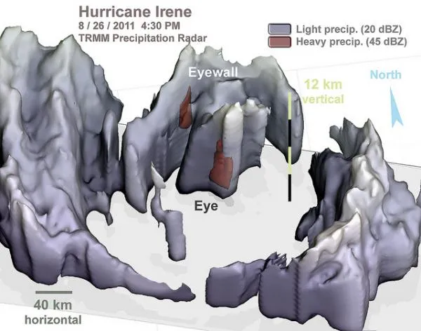
NASA's Tropical Rainfall Measuring Mission (TRMM) satellite radar produces three-dimensional images of storms' precipitation, and on Friday afternoon (Aug. 27) the radar showed that the southern half of Hurricane Irene's eyewall was gone.
Some strong precipitation did still exist in the remaining eyewall to the north of the eye.
Latest Videos From
The weakening of the inner-core precipitation structure as Irene approached North Carolina was similar to the pre-landfall weakening of the inner-core of Hurricane Isabel in 2003, the most recent hurricane to make landfall in North Carolina's Outer Banks.
TRMM showed that the highest towering thunderstorms were about 7.5 miles (12 kilometers) high.
Just before 8 a.m. EDT, on Saturday, August 27, Hurricane Irene made landfall near Cape Lookout, North Carolina.
The storm is a Category 1 hurricane packing maximum sustained winds of 85 mph (140 kmh) centered over eastern North Carolina, and moving north at 13 mph (20 kph), according to the most recent update from the National Hurricane Center. The storm is forecast to continue up the east coast.
Irene's hurricane-force winds extend 90 miles (145 km) from the center or 180 miles (290 km) in diameter. Tropical-storm force winds extend out 260 miles (418 km) from the center, making Irene about 520 miles (837 km) in diameter.
While Hurricane Irene is forecast to pass along the East Coast all the way to New England and then into Canada, the Friday afternoon overflight may be the last well-centered TRMM radar overflight because the orbit of the TRMM satellite stays within 35 degrees of latitude from the Equator.