This week, a ferocious storm ripped through the Midwest; those who experienced it where hit with strong winds, rain, hail, snow and widespread tornadoes.
The National Weather Service (NWS) reported on Oct. 26 that the Midwest storm had set a record for the lowest pressure (not associated with a hurricane) measured over land in the continental United States, with a barometric pressure of 28.20 inches or 955 millibars. That pressure reading is most typically recorded during a Category 3 hurricane with 115 mph (185 kph) winds.
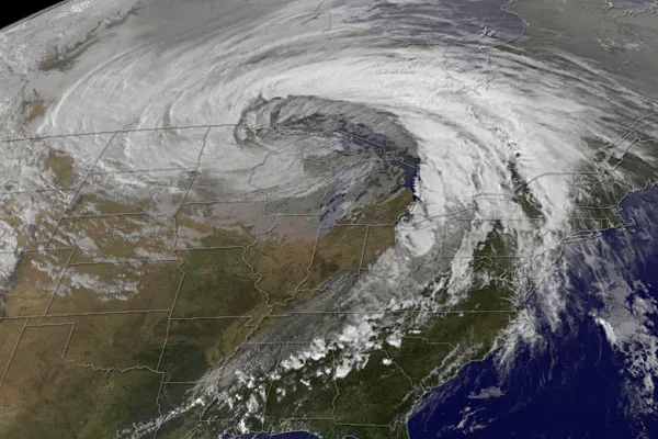
This image, taken by NASA's GOES satellite on Oct. 26, shows the storm system circling around the area of extreme low pressure.
Latest Videos From
Extratropical cyclones storms that form outside the tropics, sometimes as a tropical storm or hurricane transition to higher latitudes such as this one form over the United States in the spring and fall, when the temperature difference from north to south is large.
Because the Earth is rotating, the air moving in the low pressure at the center of the storm ends up circling the area of low pressure, creating the cyclone shown in the image. The intensity of the storm is determined by the pressure difference between the center and the outer edges. Extreme low pressure in the center of the storm, therefore, is an indicator that the storm was very intense.
Tentacles of this 'super-storm' reached from southern Louisiana in the south, to Newfoundland, Canada, in the northeast and as far westward as Montana at its peak strength on Oct. 26, covering over 2.5 million square miles (6.5 million square kilometers) of territory.
During the storm, winds gusted up to 78 mph (126 kph) in Michigan, with high winds throughout the Midwest. The National Weather Service reported 61 tornadoes over two days, and heavy snow fell in the north.

 Live Science Plus