


Hurricane Season's Second Peak Is Here
While the 2012 Atlantic hurricane season is winding down, experts expect another hurricane or two before it's over.
The really busy part of the season — typically August and September — is over, but this week marks the second "peak" of the hurricane season; on average, cyclones are more likely to form this week than any time in the last three weeks of the season, said Brian McNoldy, a hurricane researcher at the University of Miami. (The official end to hurricane season is Nov. 30.)
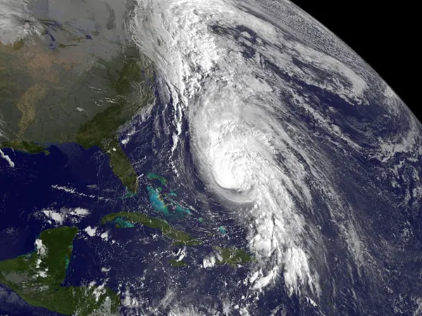
That's due to a shift in the areas where cyclones form; now they are most likely to originate in the Gulf of Mexico and the western Caribbean. These storms tend to curve toward the northeast, explaining why October is the worst month for hurricanes in Florida. Hurricane Rafael, spawned this week in the eastern Caribbean, is an example of a second peak storm and only the latest cyclone to form in an above-average year.

Moving West
In the summer leading up to the true peak of the hurricane season on Sept. 10, cyclones are most likely to form in the eastern and mid-Atlantic Ocean, often in the tropics or subtropics. But conditions there are becoming less hospitable to hurricane formation, mainly due to an increase in wind shear, which is an imbalance between winds at the surface and higher up in the atmosphere.
Wind shear is caused by differences in atmospheric pressure between neighboring regions and reduces the strength of cyclones by separating their warm core from the system of circulation above it. Cyclones are basically large heat engines that are driven by a temperature difference between the warm ocean surface and the cool atmosphere above; wind shear disrupts this pattern of circulation and weakens storms. [Storm Season! How, When & Where Hurricanes Form]
Now, hurricanes are more likely to form farther west, in the Caribbean and Gulf of Mexico, McNoldy told OurAmazingPlanet. In those areas, there is an abundance of warm water ready to fuel nascent cyclones. On average, surface temperatures need to be at least 78 degrees Fahrenheit (26 degrees Celsius) to fuel hurricanes, according to the National Oceanographic and Atmospheric Administration (NOAA). A map made by NOAA on Oct. 16 shows thick layers of water above this temperature throughout the region. This westward shift accounts for the slight peak in the number of hurricanes and tropical storms this week, on average throughout the 160 or so years hurricane records have been kept, he said.
Get the world’s most fascinating discoveries delivered straight to your inbox.
At this point in the year, weather systems are more likely to reach farther south than earlier in the season, McNoldy said. That's because there is more cold air over North America, making cold fronts stronger and better able to penetrate further south, he said. These cold fronts often produce low pressure systems that pull in moisture-rich air from nearby, which tends to rise and create thunderstorms in a swirling pattern. Given the right conditions and enough time to grow over the warm waters of the Gulf and Caribbean, these systems can become tropical cyclones, he said. (Tropical cyclone is a generic term for hurricanes, tropical storms and typhoons.)
October hurricanes
October is also the month that Florida is most likely to be struck by a hurricane, thanks to the increased likelihood of cyclones coming out of the Gulf or Caribbean, which tend to curve to the northeast. Basically, "Florida is in the way," McNoldy said.

He estimates that there is an 8 percent chance that a hurricane will hit Florida in the remainder of the season. There's ample historical precedent for this. One such cyclone that originated in the western Caribbean and struck Florida was Hurricane Wilma, in 2005, the most powerful hurricane in the history of the Atlantic basin, McNoldy said. It was the fourth most costly storm in American history.
Florida aside, McNoldy expects that there will be another hurricane somewhere in the Atlantic basin before the year's end, he said.
Above average
This hurricane season has been slightly more active than average, McNoldy said, with nine hurricanes and 17 named storms. (Storms are named in the Atlantic once they achieve tropical storm strength.)
This week witnessed the birth of Hurricane Rafael, in the eastern Caribbean. Rafael had characteristics of both early-season and late-season Caribbean cyclones, McNoldy said; it formed from a tropical wave, like many storms that originate out in the Atlantic, but curved to the north like a Caribbean cyclone.
If another cyclone forms this year, it will likely form as an offshoot of a cold front moving south, he said. If it does form and becomes at least a tropical storm, it will be named Sandy, the next name on the 2012 hurricane name list.
Reach Douglas Main at dmain@techmedianetwork.com. Follow him on Twitter @Douglas_Main. Follow OurAmazingPlanet on Twitter @OAPlanet. We're also on Facebook and Google+.
