


Gulf Woes Grow as Hurricane Threat Mounts
With Hurricane Alex churning through the Gulf of Mexico Wednesday and this year's hurricane season forecasted to be an active one, scientists are worried about how the Gulf Coast will fare from the potential wallop it could take.
Right now, scientists are predicting that this hurricane season, which officially began on June 1, could be as intense as or worse than in 2005 (the most active Atlantic season ever recorded and the year Hurricane Katrina struck).
This stormy weather has the potential to not only wreak the normal havoc on coastal areas, toppling trees and flooding inland areas, but could worsen the already devastating impact of the BP oil spill on the Gulf, spreading tar balls over a much wider area, as well as across not-yet-hit marshes, according to Ping Wang in the Department of Geology at the University of South Florida. Already, Alex has pushed oil from the spill onto Gulf coast beaches, with some tar balls as large as apples, according to news reports.
There are many unknowns to how the hurricane season could play out, including the location and track of each hurricane, which could impact where the oil ends up and whether the end result actually helps rid the beaches of oil or piles it on. How intense each hurricane will be is also pretty fuzzy, even when a hurricane has fully formed.
"As far as the Gulf and the oil slick, it doesn't take much of a hurricane to make a fairly big difference there in being able to drive oil ashore. Any storm that comes through is not good news," said Greg Holland of the National Center for Atmospheric Research in Boulder, Colo., which is sponsored by the National Science Foundation (NSF).
Holland is part of a panel of scientists who will brief the U.S. House and Senate on Wednesday about upcoming hurricanes, how they relate to climate change and the storms' possible effects on the Gulf oil slick.
Key ingredients for the perfect storm
Get the world’s most fascinating discoveries delivered straight to your inbox.
"Alex is definitely just the beginning," Holland said, adding that he doesn't usually buy into predictions for the coming season's forecast for hurricanes. "But in this particular season it's so far out on the extreme I think we do need to warn people on the potential."
Holland said various ingredients come together to suggest Mother Nature could churn out some intense hurricanes.
For one, the sea surface temperatures in the North Atlantic, known to drive the bulk of hurricane formation, are even higher than they were in 2005, about 1 degree Fahrenheit (1 to 1.5 degrees Celsius) warmer than 2005 (which already was warmer than average).
"The globe is plain and simply warming up," Holland said. Hurricanes are fed by moisture off the ocean, and warmer waters mean more moisture evaporates into the atmosphere. The result is analogous to driving a car with "high-octane fuel," Holland said.
In addition, the warming waters in the Atlantic along with the cooling waters in the eastern Pacific change the wind circulation patterns in a way that creates favorable hurricane weather, Holland added. And not just favorable conditions anywhere, but specifically in the hub of intense Atlantic hurricane development.
About 80 percent of all hurricanes that affect the United States, and just about all Category 5 hurricanes (the strongest on the hurricane strength scale), are formed in a hub region off Cape Verde, Africa. Storms are spit off the west African coast and can be fed by the warm waters of the equatorial Atlantic, gaining strength as they travel from east to west across the Atlantic. Not all Atlantic storms form here though, as they can form elsewhere in the North Atlantic, Caribbean and Gulf of Mexico.
Wherever a hurricane forms, scientists try to use models to predict the path it will take. Hurricane-prediction science still isn't at the point where one could determine in advance whether the intense storms will hit the Gulf though.
But the more storms there are, the greater the potential for one to slam a critical area on the Gulf, Holland said.
Also the atmospheric phenomenon called El Nino has recently ended while La Nina is ramping up, meaning a cooling in the equatorial Pacific Ocean and a steering of the polar jet stream (which delivers wintry weather) farther north. That jet stream can act as a speed bump for hurricanes and with it moving farther north, storms that form in the tropical Atlantic can continue westward (sometimes toward the Gulf) unimpeded, said Bill Patzert, an oceanographer and climatologist at NASA's Jet Propulsion Laboratory in Pasadena, Calif.
Strong hurricanes are often seen in La Nina summers and falls, Patzert said.
How hurricanes and Gulf oil mix
When a hurricane, like Alex, hits the Gulf, there's likely to be upwelling of water that would generally mix up the water and oil. That's good news, because the dispersed oil would be easier for bacteria to break down and consume than the larger clumps.
But hurricanes also by their very nature move in a counter-clockwise direction and so tend to move water from east to west — the opposite direction from the way the oil has generally been spreading so far.
"The water that's east of the Mississippi Delta, when it gets driven to the west, it'll run into the delta and it's going to find its way into the marsh lands there," said Rick Luettich, director of the Marine Sciences Institute at the University of North Carolina, Chapel Hill. "That's just by virtue of the fact that the coast of Louisiana has this big thing jutting out," he added, referring to the marshy area of the state south of New Orleans that sticks out like a foot into the Gulf.
If there's oil in the water that gets pushed westward by the hurricane, the gunk will also make its way into the marshes, said Luettich, who is also at the UNC Center for Natural Hazards and Disasters. Luettich received a National Science Foundation (NSF) rapid-response grant to investigate the oil spill.
But "if there's not oil in the water then that actually could help flush out the marshes if there's any oil that made its way into the marshes earlier," he said.
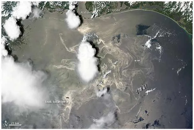
Satellite maps of the Gulf oil slick put out by the National Oceanic and Atmospheric Administration (NOAA) show the surface oil is currently piling up to the east of the delta. "If that remains the case is that all of that oil is likely to get pushed to the west and right up into the Louisiana marshes," Luettich said during a telephone interview Tuesday.
Ongoing research by Wang and his colleagues suggests tar balls have already made landfall along Alabama and Mississippi beaches, where the clumps of oil get buried quickly within the sand. The surf created by a hurricane could send even more oil ashore.
"When we have a storm we'll have a storm surge, the water level will get elevated and you also have big storm waves," Wang told LiveScience. "The waves and water can get onto the beach much farther inland than on a typical day. So the oil may be distributed over a much wider zone."
So far, Alex doesn't seem to be much of a threat to the areas impacted by the oil spill. "It looks like mainly we're going to see that east-to-west motion associated with the far-field winds of Alex," Luettich said. "The good news, it's far enough away it doesn't look like it'll have a large impact."
Even so, the high winds and choppy seas could slow down if not stop oil cleanup operations, Patzert said. News reports suggest some cleanup operations have already been sidelined due to Alex's ripple effects.
Hurricane unknowns
Like Alex, each tropical cyclone (the broad name for hurricanes and tropical storms) has its own path and so making specific predictions about how such natural disasters might send oil onto one coastal spot over another can be tricky.
For instance, because of the nature of hurricanes the oil and water on the eastern, or right-hand side, of the storm will tend to get pulled toward shore, while that on the storm's western side will tend to get pulled offshore. "That's entirely dependent on where the storm hits," Luettich said.
Scientists also can't predict with any certainty the intensity of an individual hurricane, though Holland said a number of trial forecast systems are being tested out this year.
More than ever, Holland advises individuals and regions to prepare for the worst, as it can only help. That includes coming up with evacuation plans if a hurricane system approaches. Some precautions are already being put into place to help keep the oil from slamming into the Gulf coast if a storm does hit.
"If we're looking at long-term, a number of us have been saying hurricanes will become more frequent," Holland said, pointing to climate change as a culprit. And so planning ahead and adjusting building regulations and societal structure are critical, he added.
- The 10 Worst U.S. Natural Disasters
- Earth in the Balance: 7 Crucial Tipping Points
- Hurricanes from Above: See Nature's Biggest Storms
Jeanna Bryner is managing editor of Scientific American. Previously she was editor in chief of Live Science and, prior to that, an editor at Scholastic's Science World magazine. Bryner has an English degree from Salisbury University, a master's degree in biogeochemistry and environmental sciences from the University of Maryland and a graduate science journalism degree from New York University. She has worked as a biologist in Florida, where she monitored wetlands and did field surveys for endangered species, including the gorgeous Florida Scrub Jay. She also received an ocean sciences journalism fellowship from the Woods Hole Oceanographic Institution. She is a firm believer that science is for everyone and that just about everything can be viewed through the lens of science.