


History Reveals Hurricane Threat to New York City
Last year, Florida took the brunt of nature's summer fury, when four hurricanes slammed into the state. While the four-part pummeling was unusual, Florida has been hit nearly twice as often as any other state as long as records have been kept.
Residents in Florida know what to do. You've seen the lines of traffic lumbering away from the coast hours and even days before a storm hits.
But what would happen if a major hurricane struck New York City?

With another hurricane season officially underway and lots of activity expected, forecasters are armed with more data and more powerful computer models than ever before. There would be some warning.
Because of the population density, a successful evacuation of vulnerable low-lying areas in and around New York City and metropolitan New Jersey would actually have to start sooner than what is typically ordered in Florida and elsewhere, officials have determined based on studies by the Army Corps of Engineers.
But hurricanes move more quickly and become very difficult to predict when they head north of the Carolinas. In a likely scenario, experts say, there might only be hours of warning.
History reveals that New York and the Northeast have been hit hard before, and with little warning. Scientists say the next major hurricane to strike the city is a question of when, not if.
Get the world’s most fascinating discoveries delivered straight to your inbox.
History forgotten
Late in the summer of 1938, a wave of energy moved off the coast of Africa. Winds were sucked into the atmospheric depression and curved by the Earth's spin into a counterclockwise rotation.
The storm churned unnoticed across the open sea, gathering strength from warm tropical waters. On Friday, Sept. 16, a Brazilian freighter reported the storm.
Gordon Dunn and Grady Norton, U.S. Weather Bureau forecasters in Florida, issued a hurricane warning for Miami, expecting the storm to hit Tuesday. Miami residents stockpiled supplies, boarded windows, secured boats.
But on Monday evening, the storm turned north and sped up to 20 mph, a swift forward speed that scientists of the time knew little about. It followed a typical path of recurvature -- resembling a giant C -- around the Bermuda High, an area of high atmospheric pressure in the mid-Atlantic that pushes air outward from its center, bouncing hurricanes off its edges like bubbles.
Dunn and Norton lost track of the storm off Cape Hatteras, North Carolina, and assumed it would curve eastward. The national weather map for Wednesday, Sept. 21, showed no hurricane, only a storm moving out to sea.
But winds had increased to 140 mph inside the beast. It moved north and picked up more forward speed.
The Bermuda High had moved to 44 degrees North latitude -- from its normal September position of thirty to thirty-five degrees -- blocking the hurricane's path and deflecting it northward. Abnormally warm water fed the storm as its forward speed increased to 60 mph! Waves tore up boardwalks in New Jersey.
No warnings were issued. It had been 117 years since the last great storm hit New York, on Sept. 23, 1821. History had been forgotten.
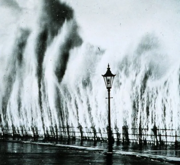
The 'fog bank'
By Wednesday afternoon, shingles were flying from roofs on Long Island. The sky grew dark. Trees were uprooted and telephone poles snapped like matchsticks. Three hours before high tide, residents reported a thick bank of gray fog, twenty-five to forty feet above the water, rolling in toward the south-facing coast.
Some residents fled to relative safety across the bridge. Many did not. Most of them died as the "fog bank" turned out to be a wall of water known as a storm surge.
Created partly by the vacuum of reduced atmospheric pressure and more so by the wind blowing over the water, the storm surge was highest in an area just east of the eye -- the right side of the storm when looked at from above. There, in the right-side eyewall, the counterclockwise winds combined with the storm's forward speed to create gusts exceeding 200 mph.
The eye of the hurricane passed some 55 miles east of Manhattan, a near miss in meteorological terms. Had it been a few miles west of Manhattan, forensic hurricanologists agree it would have devastated the island.
Drowned at work
The storm marched north. In Rhode Island, residents joked about putting up storm shutters. Finally, at least a warning had been issued. But the ferocity of the hurricane was no match for any last-minute preparations that might have been made.
At the head of Narragansett Bay, 30 miles from the Atlantic, the city of Providence awaited a fate its inhabitants could not have imagined. As the hurricane barreled toward the city, it pushed a surge of water up the bay. As the channel narrowed and became more shallow, the storm surge had nowhere to go but up.
The mountain of water carried boats and houses into the capital, flooding the first floor of buildings in downtown, where workers were just preparing to go home. Having no idea what a storm surge was, many of them were trapped and drowned where they worked. The surge of water caused tides (and even non-tidal sections of rivers) to rise 30 feet and more above normal levels.
Later that night, the Great New England Hurricane reached Canada, weakened but still potent enough to cause damage.
Over a four-day period, the 1938 storm dropped an average of 11 inches of rain over a 10,000-square-mile area, according to the National Weather Service. Flooding inflicted major damage through Connecticut, Massachusetts, New York, and Vermont, causing more than $300 million in losses.
In all, 600 people died. Ten of those deaths were in New York City. Flooding knocked out electrical power in all areas above 59th Street in Manhattan and in all of the Bronx. A hundred large trees in Central Park were destroyed.
Related Stories
- Subway Flooding: A Hidden and Neglected Risk
- How & Where Hurricanes Form
- Top 10 Ways to Destroy Earth
Off the Beaten Track
NOAA
Scary New York Moments
Some of the worst hurricane-related effects in New York's history:
1821: The only hurricane in modern times known to pass directly over parts of New York City pushed the tide up 13 feet in one hour and inundated wharves, causing the East River and the Hudson River to merge across lower Manhattan as far north as Canal Street. Deaths were limited since few lived there at the time.
1893: A category 1 hurricane destroyed Hog Island, a resort island off the Rockaways in southern Queens.
1960: Hurricane Donna created an 11-foot storm tide in the New York Harbor that caused extensive pier damage. Forced 300 families to evacuate Long Island.
1999: Floyd, weakened to a tropical storm, brought sustained 60 mph winds and dumped 10-15 inches of rain on upstate New Jersey and New York State.
2004: The remains of Hurricane Frances in September flooded city subways, stranding some passengers aboard trains that had to be stopped by flooded tracks.
SOURCE: New York City Office of Emergency Management, LiveScience reporting

Robert is an independent health and science journalist and writer based in Phoenix, Arizona. He is a former editor-in-chief of Live Science with over 20 years of experience as a reporter and editor. He has worked on websites such as Space.com and Tom's Guide, and is a contributor on Medium, covering how we age and how to optimize the mind and body through time. He has a journalism degree from Humboldt State University in California.