US Weather Blew Hot and Cold in February

Weather patterns drew a dividing line between the western and eastern United States in February, according to NASA.
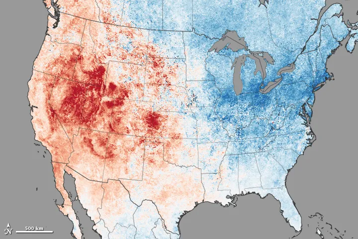
While Westerners bemoaned their drought and Easterners complained about snow, the Moderate Resolution Imaging Spectroradiometer (MODIS) on NASA's Terra satellite mapped land surface temperatures last month, recording where the temperature rose above and fell below the average. (Land surface temperatures are often warmer than air temperatures.)
The map revealed a temperature break — between record heat and winter's chill — that ran from North Dakota south to Alabama, along the Rocky Mountain foothills.
Article continues belowAlthough much of the West experienced temperatures that were more than 18 degrees Fahrenheit (10 degrees Celsius) above average, states from the Plains to the Atlantic Coast were 18 F below normal, according to NASA's Earth Observatory.
Although statewide data showed that no state set a new record for cold temperatures in February, many cities broke their all-time winter lows and set new snowfall records to boot. For example, Worcester, Massachusetts, shivered through its coldest February on record, with an average air temperature of 14 F (minus 10 C), and Syracuse, New York, broke its old February record by 3 F (1.6 C), setting a new low of 9.1 F (minus 13 C).
Meanwhile, record-high monthly temperatures were set in California, Nevada, Utah and Washington during the month, according to the National Oceanic and Atmospheric Administration (NOAA).
Researchers are looking at several possible causes for the unusual weather patterns seen last month, Mike Halpert, deputy director of NOAA's Climate Prediction Center, told Live Science on March 6. One important player could be the Pacific Ocean, which is much warmer than usual offshore the Pacific Northwest. The warmth may have pushed the jet stream into a position that sucked cold, Arctic air down toward the Northeast and also blocked moisture-laden storms from reaching California.
Get the world’s most fascinating discoveries delivered straight to your inbox.
Follow Becky Oskin @beckyoskin. Follow Live Science @livescience, Facebook & Google+. Originally published on Live Science.
