 Live Science Plus


You are now subscribed
Your newsletter sign-up was successful
Want to add more newsletters?

Delivered Daily
Daily Newsletter
Sign up for the latest discoveries, groundbreaking research and fascinating breakthroughs that impact you and the wider world direct to your inbox.

Once a week
Life's Little Mysteries
Feed your curiosity with an exclusive mystery every week, solved with science and delivered direct to your inbox before it's seen anywhere else.

Once a week
How It Works
Sign up to our free science & technology newsletter for your weekly fix of fascinating articles, quick quizzes, amazing images, and more

Delivered daily
Space.com Newsletter
Breaking space news, the latest updates on rocket launches, skywatching events and more!

Once a month
Watch This Space
Sign up to our monthly entertainment newsletter to keep up with all our coverage of the latest sci-fi and space movies, tv shows, games and books.

Once a week
Night Sky This Week
Discover this week's must-see night sky events, moon phases, and stunning astrophotos. Sign up for our skywatching newsletter and explore the universe with us!
Join the club
Get full access to premium articles, exclusive features and a growing list of member rewards.
Tropical Storm Andrea
Tropical Storm Barry

NOAA's GOES-13 satellite captured a visible image of Tropical Storm Barry just after it became a tropical storm on June 19, 2013, in the Bay of Campeche. Barry initially formed as a tropical wave in the Caribbean Sea, then traveled over the Yucatan Peninsula, bringing drenching rains. It made its second landfall over Veracruz, Mexico, on June 20.
Tropical Storm Chantal

NASA’s Terra satellite captured this stunning visible image of Tropical Storm Chantal over the Lesser Antilles on July 10, 2013. Chantal dumped rain on the island of Hispaniola, causing flooding.
Tropical Storm Dorian

This night-time, infrared image of Tropical Storm Dorian was taken from the VIIRS instrument aboard the Suomi-NPP satellite on July 25, 2013. The red and purple colors represent the storm's coldest cloud tops, or it's highest thunderstorms, which were also its strongest.
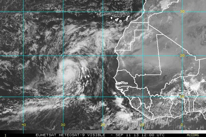
Tropical Storm Erin

Newly formed Tropical Storm Erin was spotted by the Meteosat 9 satellite on Aug. 15, 2013, when it was bout 150 miles (240 kilometers) southwest of the Cape Verde islands.
Tropical Storm Fernand

The GOES-East satellite snapped this image of Tropical Storm Fernand at 7:45 a.m. EDT on Aug. 26, and shows how the storm expanded after making landfall before quickly dissipating.
Tropical Storm Gabrielle

NASA's Aqua satellite passed over the resurrected Tropical Storm Gabrielle on Sept. 10 at 0559 UTC/1:59 a.m. EDT and detected cloud-top temperatures of powerful thunderstorms (purple).
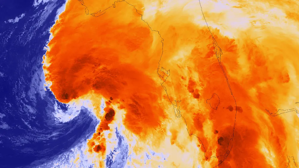
Hurricane Humberto
Hurricane Humberto appears as a characteristic swirl in the Eastern Atlantic on the morning of Sept. 11, 2013. Humberto was the first hurricane of the 2013 season and narrowly missed being the latest-forming hurricane on record (a title held by 2002's Hurricane Gustav, which formed three hours later than Humberto on Sept. 11 of that year).
Hurricane Ingrid

NASA's TRMM satellite flew over Hurricane Ingrid in the Gulf of Mexico on Sept. 16, 2013. It's precipitation measurements showed that rain was falling from the storm at a rate of about 4 inches (100 millimeters) per hours. The storm caused significant flooding and landslides along the Gulf coast of Mexico.
Tropical Storm Jerry

After Tropical Storm Jerry weakened into a tropical depression, it dissipated over the eastern Atlantic. This was the last forecast path issued by the National Hurricane Center for the storm.
Tropical Storm Karen over the Gulf Coast as viewed by the GOES-1 satellite on Oct. 4.

Tropical Storm Karen over the Gulf Coast as viewed by the GOES-East satellite on Oct. 4.

