 Live Science Plus


How a Fake Island Landed on Google Earth
You are now subscribed
Your newsletter sign-up was successful
Want to add more newsletters?

Delivered Daily
Daily Newsletter
Sign up for the latest discoveries, groundbreaking research and fascinating breakthroughs that impact you and the wider world direct to your inbox.

Once a week
Life's Little Mysteries
Feed your curiosity with an exclusive mystery every week, solved with science and delivered direct to your inbox before it's seen anywhere else.

Once a week
How It Works
Sign up to our free science & technology newsletter for your weekly fix of fascinating articles, quick quizzes, amazing images, and more

Delivered daily
Space.com Newsletter
Breaking space news, the latest updates on rocket launches, skywatching events and more!

Once a month
Watch This Space
Sign up to our monthly entertainment newsletter to keep up with all our coverage of the latest sci-fi and space movies, tv shows, games and books.

Once a week
Night Sky This Week
Discover this week's must-see night sky events, moon phases, and stunning astrophotos. Sign up for our skywatching newsletter and explore the universe with us!
Join the club
Get full access to premium articles, exclusive features and a growing list of member rewards.
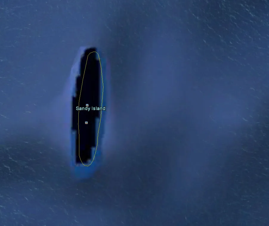
Last year, a group of Australian researchers "undiscovered" an island the size of Manhattan in the South Pacific.
A mysterious place called Sandy Island had popped up on maps, northwest of New Caledonia. It even showed up as a black polygon on Google Earth. But when scientists sailed there last November, they found open water instead of solid ground.
Sandy Island was first recorded by the whaling ship Velocity in 1876 and first mentioned on a British Admiralty chart in 1908. But future expeditions failed to find the island, and it was removed from some official hydrographic charts by the 1970s.
However, the errant island stuck on some maps and then crept into digital databases like the widely used World Vector Shoreline Database, which was developed by the U.S. military.
"During the conversion from hard-copy charts to digital formats the 'Sandy Island' error was entrenched," said Maria Seton, of the University of Sydney. (Seton was chief scientist on an expedition to study plate tectonics on the RV Southern Surveyor when the "undiscovery" was made.)
"We all had a good giggle at Google as we sailed through the island," Steven Micklethwaite, a scientist at the University of Western Australia who was on the voyage, told the Sydney Morning Herald at the time of the undiscovery. "Then we started compiling information about the seafloor, which we will send to the relevant authorities so that we can change the world map."
![Taken in the afternoon on July 19, 2012, this NASA MODIS image reveals the Havre Seamount eruption, including the gray pumice, ash-stained water and the volcanic plume. [Wild Volcano Images]](https://cdn.mos.cms.futurecdn.net/7sG4tpdfiy7YykD32ji9Sa-720-80.jpg.webp)
But what did the crew of the Velocity see in the first place that led to the false discovery of Sandy Island in the 19th century? Seton and her colleagues speculate that it might have been a giant pumice raft.
Pumice forms when volcanic lava cools quickly, trapping gas inside and creating lightweight rocks that can float. Last summer, an erupting undersea volcano called the Havre Seamount sent pumice drifting off the coast of New Zealand across an astounding area of 8,500 square miles (22,000 square kilometers). And Sandy Island happens to sit along a pumice "superhighway."
"It is believed that wind and ocean surface currents in the area combine to funnel pumice rafts through the area between Fiji and New Caledonia on their way to Australia," Seton and her colleagues wrote in an article in the journal EOS. "The formation of this 'pumice raft superhighway,' which passes by the location of Sandy Island, lends weight to the idea that the Velocity may have captured a moment when some sea‐rafted pumice was traversing the area."
Follow Megan Gannon on Twitter and Google+. Follow us @livescience, Facebook & Google+. Original article on LiveScience.com.

