What is a Jet Stream?

Jet streams are like rivers of wind high above in the atmosphere. These slim strips of strong winds have a huge influence on climate, as they can push air masses around and affect weather patterns.
The jet streams on Earth — other planets have jet streams as well, notably Jupiter and Saturn — typically run from west to east, and their width is relatively narrow compared to their length. Jet streams are typically active at 20,000 feet (6,100 meters) to 50,000 feet (9,144 meters), or about 7 miles (11 kilometers) above the surface and travel in what is known as the troposphere of Earth’s multi-layered atmosphere.
While they are fairly narrow, they cover a wide latitude running north to south and often travel a very winding path; at times they can even fade away or break off into smaller “rivers” of air that merge again “downstream.”
Article continues belowThe seasons of the year, location of low and high pressure systems and air temperature all affect when and where a jet stream travels. Jet streams form a border between hot and cold air. Because air temperature influences jet streams, they are more active in the winter when there are wider ranges of temperatures between the competing Arctic and tropic air masses.
Temperature also influences the velocity of the jet stream. The greater the difference in air temperature, the faster the jet stream, which can reach speeds of up to 250 mph (402 kph) or greater, but average about 110 mph (177 kph).
Both the Northern and Southern hemispheres have jet streams, although the jet streams in the north are more forceful. Each hemisphere has two primary jet streams — a polar and a subtropical. The polar jet streams form between the latitudes of 50 and 60 degrees north and south of the equator, and the subtropical jet stream is closer to the equator and takes shape at latitudes of 20 to 30 degrees.
While the polar and subtropical jet streams are the best known and most studied, other jet streams can form when wind speeds are above 58 mph (93.3 kph) in the upper atmosphere at about 6 miles (9.6 kilometers) to 9 miles (14.5 kilometers) above the surface. The term is often misued, even by meteorologists giving the weather forecast who sometimes, for the sake of simplicity, call all strong upper-atmosphere winds jet streams.
Get the world’s most fascinating discoveries delivered straight to your inbox.

Jet Streams and the weather
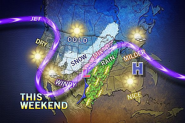
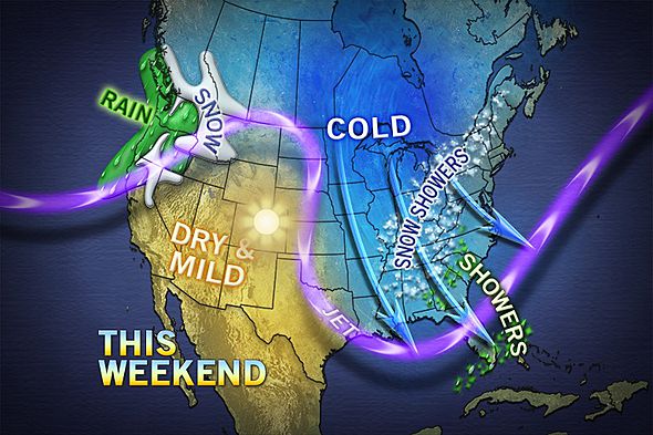
Jets streams play a key role in determining the weather because they usually separate colder air and warmer air. Jet streams generally push air masses around, moving weather systems to new areas and even causing them to stall if they have moved too far away.
While they are typically used as one of the factors in predicting weather, jet streams don’t generally follow a straight path — the patterns are called peaks and troughs — so they can shift, causing some to point at the poor forecasting skills of meteorologists.
Climatologists say that changes in the jet streams are closely tied to global warming, especially the polar jet streams, because there is a great deal of evidence that the North and South poles are warming faster than the remainder of the planet. When the jets streams are warmer, their ups and downs become more extreme, bringing different types of weather to areas that are not accustomed to climate variations. If the jet stream dips south, for example, it takes the colder air masses with it.
Jet streams also have an impact on air travel and are used to determine flight patterns. An airplane can travel much faster, and save fuel, by getting “sucked up” in the jet stream. That can also cause a bumpy flight, because the jet stream is sometimes unpredictable and can cause sudden movement, even when the weather looks calm and clear.
Who discovered jet streams?
Aeronautics played a role in the discovery and mapping of jet streams. Many credit bomber pilots flying missions during World War II with much of the knowledge we have today about the jet streams. They were able to quicken their missions and beat hasty retreats over the Mediterranean Sea by making the most of the jet streams.
But even before WWII bomber pilots used the jet streams. Wiley Post, an American pilot and the first to fly solo around the world in 1933, contributed to our knowledge of these forces of nature. He developed a pressurized suit to fly higher in the atmosphere and noted the differences in pressure at various levels. This set the stage for the understanding of the jet stream and pressurized flight.
German meteorologist H. Seilkopf is often credited with coining the phrase "jet stream," as he used in a research paper published in 1939.
Volcanoes have also played a role in understanding of the jet stream. Observers of the 1883 eruption of the Krakatoa volcanic island in Indonesia documented its effect on the sky, and in the 1920s Japanese meteorologist Wasaburo Oishi used aviator balloons to identify the jet stream from a site near Mt. Fuji.
More recently, many European flights were grounded after the 2009 eruption of Iceland's Eyjafjallajokull volcano —further proof that plumes of volcanic ash have a tendency to get sucked into the same jet stream that airplanes use for travel.
Kim Ann Zimmermann is a contributor to Live Science and sister site Space.com, writing mainly evergreen reference articles that provide background on myriad scientific topics, from astronauts to climate, and from culture to medicine. Her work can also be found in Business News Daily and KM World. She holds a bachelor’s degree in communications from Glassboro State College (now known as Rowan University) in New Jersey.