 Live Science Plus


You are now subscribed
Your newsletter sign-up was successful
Want to add more newsletters?

Delivered Daily
Daily Newsletter
Sign up for the latest discoveries, groundbreaking research and fascinating breakthroughs that impact you and the wider world direct to your inbox.

Once a week
Life's Little Mysteries
Feed your curiosity with an exclusive mystery every week, solved with science and delivered direct to your inbox before it's seen anywhere else.

Once a week
How It Works
Sign up to our free science & technology newsletter for your weekly fix of fascinating articles, quick quizzes, amazing images, and more

Delivered daily
Space.com Newsletter
Breaking space news, the latest updates on rocket launches, skywatching events and more!

Once a month
Watch This Space
Sign up to our monthly entertainment newsletter to keep up with all our coverage of the latest sci-fi and space movies, tv shows, games and books.

Once a week
Night Sky This Week
Discover this week's must-see night sky events, moon phases, and stunning astrophotos. Sign up for our skywatching newsletter and explore the universe with us!
Join the club
Get full access to premium articles, exclusive features and a growing list of member rewards.
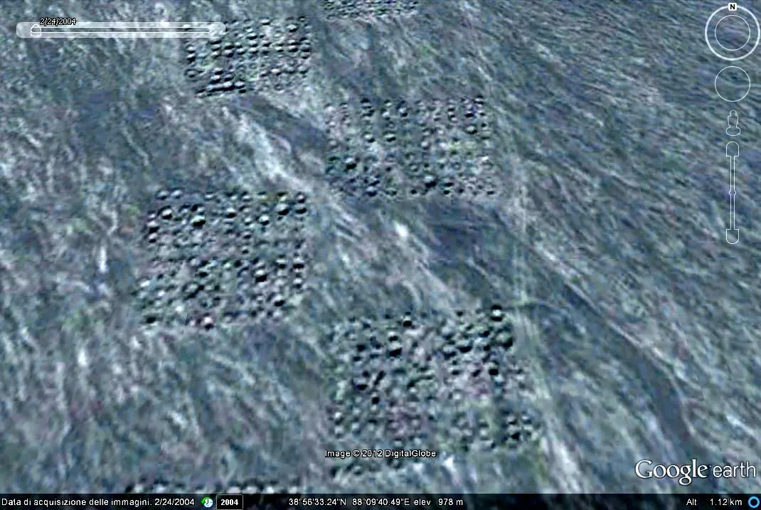
A mysterious grid of dots spanning several miles of Western China's sand dunes like a giant chessboard may be the result of geological surveys for nickel mines, according to new analysis of satellite images of the area.
"In the satellite maps, we can see a man-made texture on the soil, a huge band which seems created by relatively small holes or mounds," wrote the study author, Amelia Carolina Sparavigna, a physicist at Italy's Polytechnic University of Turin, on Oct. 25 on the website arXiv.org, ahead of publication to a scientific journal. "This curious texture on the desert soil was probably produced by the pinpointing of geophysical [research]."
In 2010, Sparavigna started investigating Google Earth satellite images of China’s remote Taklamakan desert to study the textures carved into the sand dunes by the wind. In the process, the amateur archaeologist found possible paths around the ruins of an ancient Silk Road Kingdom called Loulan. For more than a thousand years, a sea of caravans laden with spices, silks and other Eastern goods passed through this arid outpost on the way to Europe.
While looking for traces of other vanished kingdoms in the area, Sparavigna discovered a mysterious grid of dots, like pinpricks laid out in the design of a chessboard, that spanned 4.8 miles (8 kilometers) across. [Photos of the Mysterious Sand Dune Shapes]
"The archaeological site is quite elusive in satellite maps, but I saw this long grid on the land," Sparavigna told LiveScience in an email.

The strange pattern was clearly man-made. In older imagery from Bing and Nokia Maps taken prior to 2004, the strange pattern wasn't visible, indicating the shapes appeared more recently.
Sparavigna then found an article in the Chinese press describing the discovery of large amounts of nickel buried under the dunes. She concluded the new shapes must be evidence of geological surveying done prior to mining the nickel reserves. Geologists often drill boreholes to determine the composition of mineral deposits below the surface.
This isn't the first time Sparavigna has analyzed satellite imagery to shed light on mysterious patterns. In 2011 she discovered strange patterns she claimed were geoglyphs in Peru, and has also weighed in on the symbolic meaning of Chinese army barracks from the 1960s.
Sparavigna thinks it may be a good idea to create a database of large-scale, man-made features like these throughout the world.
“In my opinion, it can anticipate mining activity and development of a region,” she said in an email.
Follow LiveScience on Twitter @livescience. We're also on Facebook & Google+.

