Where Will Hurricane Dorian Make Landfall?
What are the chances the Florida coast will get a direct wallop from this monster of a storm?
Hurricane Dorian, now a Category 4 storm, continues to pound the island of Grand Bahama with powerful winds and massive amounts of rainfall. When it finally crawls past the Bahamas, one of the key questions is: Where will Dorian make landfall in the United States, if at all?
Plenty of eyes are trained on this massive storm, with sustained winds having died down a bit from earlier this morning — as of 11 a.m. it was packing 155 mph (250 km/h) max sustained winds. The National Hurricane Center (part of the National Weather Service) issued hurricane warnings for the east coast of Florida northward to the Flagler/Volusia county line.
Though forecasters don't expect the storm will hit Florida directly, that's still a possibility.
Related: History's 8 Most Destructive Hurricanes
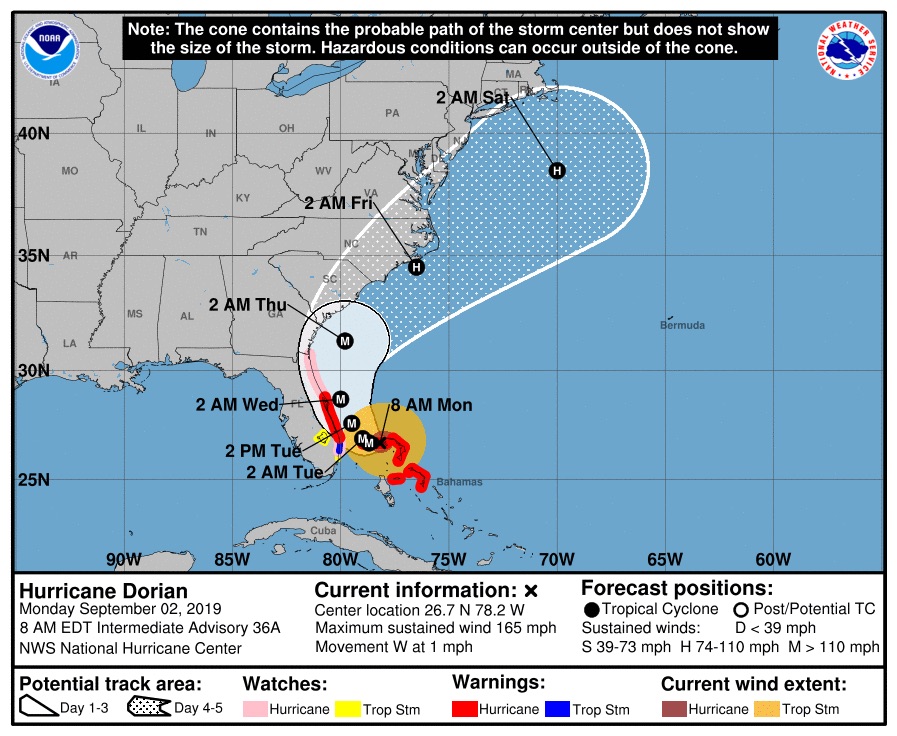
"Right now, the forecast is the most likely scenario," said Joel Cline, a meteorologist with the National Weather Service (NWS). That forecast puts Dorian on track to just miss the east coast of Florida, moving northward toward Georgia. Then, the powerful cyclone is expected to inch "very, very close to, if not make landfall in South Carolina or North Carolina," Cline told Live Science.
"That being said, there's a reason we use a cone, because it is a degree of uncertainty," he said, referring to the areas to the right and left of the storm's most likely track.
"There could be a landfall in Florida, [but] we don't see that as a likely scenario at this time," he added.
Get the world’s most fascinating discoveries delivered straight to your inbox.

Here's Hurricane Dorian's predicted path as of 8 a.m. on Sept. 2, 2019.
As of 11 a.m. ET, Dorian was moving westward at about 1 mph (2 km/h) and is situated some 110 miles (180 kilometers) east of West Palm Beach, Florida.
Related: Hurricane Season 2019: How Long It Lasts and What to Expect
The storm's path has been tricky to predict, as an "atmospheric steering wheel" that was nudging Dorian northward weakened. That weakening is also the reason Hurricane Dorian is inching so slowly over the Bahamas.
"Now, there's a trough of low pressure coming along, starting to bring it toward the north/northwest and parallel [to] the coast," Cline explained.
That low-pressure system is moving down from the Great Lakes region and is expected to intercept and bump Dorian northward late today and Tuesday, Lance Wood, an NWS meteorologist told Live Science yesterday.
The timing of that interception — and the resulting turn northward — is key to whether (and where) Dorian will make U.S. landfall.
"The turn would have to happen much later than we anticipate for it to move over Florida," Cline said.
As for what else could impact Dorian's path, Cline said there are all kinds of factors, including other tropical systems developing throughout the Atlantic Ocean that could interact with Dorian.
- Hurricanes from Above: Images of Nature's Biggest Storms
- Photos: Hurricane Michael Toppled Over Trees and Uprooted 19th Century Artifacts
- Inside Irma's Eye: Hurricane Hunters Capture Jaw-Dropping Photos
Originally published on Live Science.
Jeanna Bryner is managing editor of Scientific American. Previously she was editor in chief of Live Science and, prior to that, an editor at Scholastic's Science World magazine. Bryner has an English degree from Salisbury University, a master's degree in biogeochemistry and environmental sciences from the University of Maryland and a graduate science journalism degree from New York University. She has worked as a biologist in Florida, where she monitored wetlands and did field surveys for endangered species, including the gorgeous Florida Scrub Jay. She also received an ocean sciences journalism fellowship from the Woods Hole Oceanographic Institution. She is a firm believer that science is for everyone and that just about everything can be viewed through the lens of science.

 Live Science Plus


