It's quick and easy to access Live Science Plus, simply enter your email below. We'll send you a confirmation and sign you up for our daily newsletter, keeping you up to date with the latest science news.
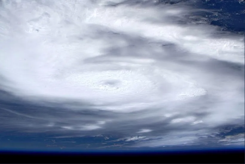
Astronaut Luca Parmitano of the European Space Agency captured this photo of the Category 5 Hurricane Dorian from the International Space Station as the storm moved across the Atlantic Ocean toward the Bahamas.
The beast of a storm has weakened slightly and is currently packing maximum sustained winds of 155 mph ( 250 km/h), according to an 11 a.m. advisory from the National Hurricane Center (NHC). The devastating Category 4 storm has been slowly passing over the main island in the Bahamas, about 110 miles (180 kilometers) east of West Palm Beach, Florida, and is moving toward the west at a sluggish 1 mph (2 km/h), the NHC said.
Dorian's movement over the next day will also help answer a big question: Will this devastating storm make landfall in Florida, or will it turn slightly north in time to spare Florida a direct hit?
The current forecast predicts a close shave and near-miss for Florida. But as Live Science previously reported, Dorian lacks an "atmospheric steering wheel" at this point, and small changes to conditions could make a big difference over the course of the next day. If the storm lumbers westward just a bit longer than predicted, Dorian's core could make landfall on Florida's eastern coastline.
Even if the Sunshine State isn't spared a direct blow, it could still face catastrophic conditions, the NHC said in the update. Parts of the eastern coast of Florida, as far north as Flagler/Volusia county line, are under a hurricane warning, with hurricane conditions expected there as soon as late tonight or Tuesday (Sept. 3).
The predicted path of Hurricane Dorian as of 8 a.m. EDT on Sept. 2.
(Image credit: NHC)
People on the east-central coast of Florida could see isolated tornadoes later today, the NHC said.
Sign up for the Live Science daily newsletter now
Get the world’s most fascinating discoveries delivered straight to your inbox.
On Grand Bahama, hurricane conditions could linger for hours, with isolated rainfall totals up to 30 inches (76 centimeters) and life-threatening storm surges of 18 to 23 feet (5 to 7 meters) possible in some locations.
Residents of Grand Bahama who are in the eye of the storm are likely feeling light winds and sunny blue skies. They should not be deceived by the calm.
"Do not venture out into the eye, as winds will suddenly increase after the eye passes," the NHC wrote in its update.
Tia is the editor-in-chief (premium) and was formerly managing editor and senior writer for Live Science. Her work has appeared in Scientific American, Wired.com, Science News and other outlets. She holds a master's degree in bioengineering from the University of Washington, a graduate certificate in science writing from UC Santa Cruz and a bachelor's degree in mechanical engineering from the University of Texas at Austin. Tia was part of a team at the Milwaukee Journal Sentinel that published the Empty Cradles series on preterm births, which won multiple awards, including the 2012 Casey Medal for Meritorious Journalism.