2-mile-tall, naked 'Marree Man' looming over Australian outback is a total mystery — Earth from space
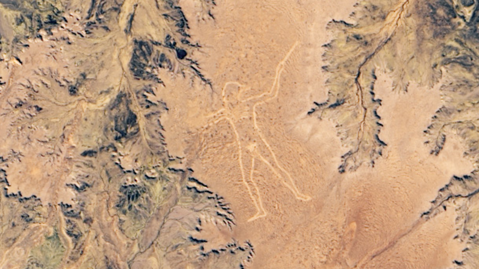
A 2019 satellite photo shows the recently resurrected "Marree Man" geoglyph, which mysteriously appeared in the Australian outback in 1998. Experts are still unsure who created it.

Where is it? Finniss Springs plateau, South Australia [-29.532472, 137.468390]
What's in the photo? A 2-mile-tall geoglyph of an Aboriginal Australian hunter carved into the ground in the outback
Which satellite took the photo? Landsat 8
When was it taken? June 22, 2019
This striking satellite photo shows a gigantic geoglyph, dubbed the "Marree Man," which suddenly appeared in the Australian outback less than 30 years ago. The origins of the Aboriginal-inspired artwork remain a mystery.
The Marree Man, also known as "Stuart's Giant," is a geoglyph — a large-scale design or symbol made by altering Earth's surface in some way. In this case, it was carved directly into the Finniss Springs plateau of South Australia, around 37 miles (60 kilometers) west of the township of Marree, according to NASA's Earth Observatory.
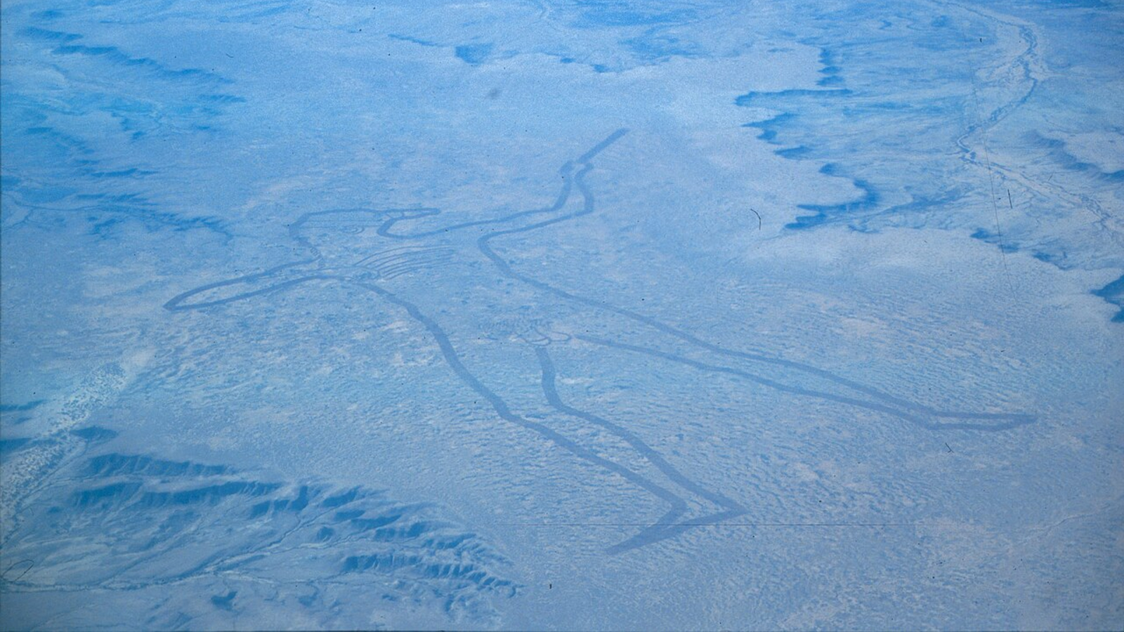
The figure's design is likely based on an Aboriginal Australian, who is depicted naked and brandishing either a "woomera" throwing stick or a boomerang. It is around 2.2 miles (3.5 km) across at its widest point, from the bottom of its feet to the tip of the weapon, while its perimeter measures around 17 miles (28 km) in total.
Compared with most other geoglyphs — such as Peru's Nazca Lines, which may date back as far as 200 B.C. — the Marree Man is extremely young, having suddenly appeared in the summer of 1998. But experts are unsure who created the towering figure or how they sketched it out so quickly.
Related: See all the best images of Earth from space

By 2016, the lines of the Marree Man, which were originally around 10 inches (25 centimeters) deep, had almost completely disappeared due to wind erosion.
As a result, local business owners decided to recarve the lines using a commercial digger and GPS guidance system, resulting in much deeper lines, according to ABC News.
Get the world’s most fascinating discoveries delivered straight to your inbox.
The retraced geoglyph, which is shown in the satellite image, should last longer than its predecessor (see below) because special grooves designed to trap water were added to its outline. In theory, this should allow vegetation to grow around its edges, giving it a longer-lasting green border, according to the Earth Observatory.
Who made the Marree Man?

The Marree Man was first discovered by a charter pilot on June 26, 1998, shortly before an anonymous fax was sent to nearby hotels, alerting the staff of the geoglyph's creation and initially naming it Stuart's Giant. (The name Marree Man was later popularized by the press.)
Satellite imagery from Landsat 8 subsequently revealed that it was created at some point during a 16-day period between May 27, when no geoglyph was visible to the satellite, and June 12, when it was first photographed from space.
It was likely created by some type of earth-moving machinery, and some experts argue that it could only be achieved using an early form of GPS mapping.
When the lines were redrawn in 2016, it took workers around 60 hours to complete the task using updated technology. The team also found 250 bamboo stakes along the perimeter, which were likely used as markers for the original, according to a 2016 article by Expedition Australia.
The most commonly proposed creator of the Marree Man was an Adelaide-based artist named Bardius Goldberg. Several of Goldberg's friends have claimed that he told them he was responsible, but he never publicly admitted this, and died in 2002.
There is also evidence that it may have been created by American personnel at a nearby Royal Australian Air Force base, as a small plaque with the U.S. flag was uncovered near the giant's head. Experts have subsequently pointed out that the anonymous fax also contained several "Americanisms," according to ABC News.
In 2018, Australian entrepreneur and explorer Dick Smith offered a 5,000-Australian-dollar (U.S. $3,700) reward for anyone with information about the geoglyph's origins, according to CNN.

Harry is a U.K.-based senior staff writer at Live Science. He studied marine biology at the University of Exeter before training to become a journalist. He covers a wide range of topics including space exploration, planetary science, space weather, climate change, animal behavior and paleontology. His recent work on the solar maximum won "best space submission" at the 2024 Aerospace Media Awards and was shortlisted in the "top scoop" category at the NCTJ Awards for Excellence in 2023. He also writes Live Science's weekly Earth from space series.
You must confirm your public display name before commenting
Please logout and then login again, you will then be prompted to enter your display name.
 Live Science Plus


