


A mysterious, mile-long landing strip in the remote Nevada desert could be the home base for testing sensors on a top-secret fleet of drones, security experts speculate.
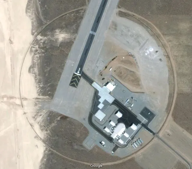
As seen in images from Google Earth, the asphalt landing strip is in Area 6 of the Yucca Flat test site, about 12 miles (19 kilometers) northeast of the infamous Area 51 that has long been the subject of conspiracy theories. In Area 6, a handful of hangars with clamshell doors are clustered at one end of the airstrip, the Google Earth images reveal.
The area, which does not have a name, is fenced off and can be seen from the road by those touring the pockmarked Nevada National Security Site of Yucca Flat, where the military conducted hundreds of nuclear tests over several decades. [14 Strangest Sights on Google Earth]
While little is known about Area 6, the Yucca Airstrip is used by both the Department of Defense and the Department of Homeland Security, Darwin Morgan, a spokesperson for the National Nuclear Security Administration, told the Las Vegas Review-Journal.
"They come here to test their own sensors," he recently said after evading questions from the newspaper about Area 6 for months.
Drone base?
Though officials with the government have been extremely reticent to reveal any details about the site, a few details have leaked out.
Get the world’s most fascinating discoveries delivered straight to your inbox.
A 7,500-page tome on nuclear safety at the Yucca Mountain nuclear waste project includes a brief paragraph describing Area 6 as an "aerial operations facility."
“The purpose of this facility is to construct, operate, and test a variety of unmanned aerial vehicles. Tests include, but are not limited to, airframe modifications, sensor operation, and onboard computer development. A small, manned chase plane is used to track the unmanned aerial vehicles,” according to a 2008 report in the Yucca Mountain repository license application filed by government contractor Bechtel SAIC, which built the airstrip for $9.6 million.
The airspace above the strip is controlled, which reduces the risk of planes or satellites in space getting a detailed look at the surroundings. It also prevents the public from unintentionally stumbling upon the site, Morgan told the Review-Journal.
Based on its size, the hangars could house up to 15 MQ-9 Reaper planes, the type of drones used to perform reconnaissance, Tim Brown, an imagery analyst at the defense information website GlobalSecurity.org, told the Review Journal. The runway is too small for fighter jets or bombers, he added.
One possibility is that the remotely piloted planes do practice runs for reconnaissance work. Yucca Flat's high desert terrain echoes that found in the most remote regions of Libya, where Al Qaeda or ISIS operatives could be hiding out, he said.
If that's the case, the government may be testing out sensor arrays — essentially fields of hundreds of smartphone-type cameras that are mounted on planes such as the MQ-9 Reaper to take time-lapse photography. The idea is that anything out there that's moving could, in fact, be moved by a potential terrorist or bad actor, Brown said.
Follow Tia Ghose on Twitterand Google+. Follow Live Science @livescience, Facebook & Google+. Original article on Live Science.

Tia is the editor-in-chief (premium) and was formerly managing editor and senior writer for Live Science. Her work has appeared in Scientific American, Wired.com, Science News and other outlets. She holds a master's degree in bioengineering from the University of Washington, a graduate certificate in science writing from UC Santa Cruz and a bachelor's degree in mechanical engineering from the University of Texas at Austin. Tia was part of a team at the Milwaukee Journal Sentinel that published the Empty Cradles series on preterm births, which won multiple awards, including the 2012 Casey Medal for Meritorious Journalism.