Live Science Plus


Hurricane Sandy's devastating storm track is a rare one among hurricanes; a new statistical analysis estimates that the track of the storm — which took an unusual left-hand turn in the Atlantic before slamming into the East Coast — has an average probability of happening only once every 700 years.
"The particular shape of Sandy's trajectory is very peculiar, and that's very rare, on the order of once every 700 years," said Timothy Hall, a senior scientist at the NASA Goddard Institute for Space Studies who co-authored the study. That means that in any particular year, the chance of such a storm track happening is 0.14 percent.
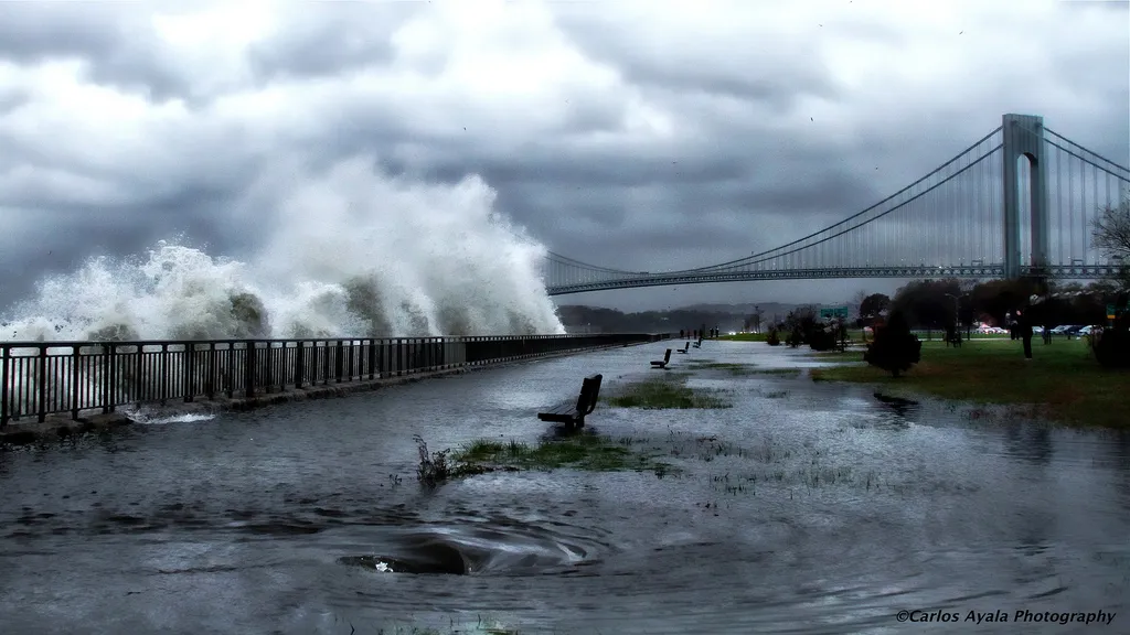
The storm's near-perpendicular strike on the coast was a major factor in the severe flooding seen in New York, New Jersey and other nearby states, Hall added. But the rareness of the storm's track doesn't mean that the coast is safe from other severe storms. [Jersey Shore: Before & After Hurricane Sandy]
Article continues below"We don't want to lead with the misimpression that we don't have to worry, [that] it's going to be 700 years until we have another surge. That's not true," Hall told LiveScience.
While Hall's initial research, detailed in the May 28 issue of the journal Geophysical Research Letters, assumed a "steady state" system in which climate is not changing, he and others are also studying how climate change influences hurricane tracks. Those studies will help determine if the rarity of paths like the one Sandy took might change in a warming world.
Plotting the storm track
Hurricane Sandy caused about 150 deaths, along with billions of dollars in damage when it hit the Caribbean and the U.S. East Coast in late October 2012. The storm's power came from a combination of factors, including its large size while out at sea and a full moon that made tides 20 percent higher than normal, both of which ramped up Sandy's storm surge.
Study researchers also pointed to weather patterns that affected Sandy's track. A region of high pressure blocked Sandy from taking a more common track out over the western North Atlantic, forcing the storm into the coast. Sandy also interacted with a mid-level, low-pressure system in the atmosphere, which helped push the storm along its unusual track.

To study the rarity of Sandy's track, Hall and his colleague, Columbia University mathematician Adam Sobel, had to use a model to generate synthetic tropical cyclones. The researchers could not rely on previously recorded data, as Sandy's trajectory and near-direct impact on New Jersey was unprecedented in the historical record.
The researchers' statistical model generated millions of these synthetic hurricanes, which were then used to determine rates for landfall. While Sandy was not a tropical storm by the time it hit the United States, the model focused on storms that originated as tropical storms, regardless of their status when they made landfall.
Most of the tracked landfalls in the model grazed the coast before veering out into the Atlantic. Sandy, by contrast, hit the coast at an angle of just 17 degrees from perpendicular, almost perfectly crisscrossing the typical storm track.
"The sustained winds towards the coast from the direct path is continually pushing a wall of water onto the coast, and you can get a greater surge magnitude," compared to more typical in-land winds sweeping along the coast, Hall said.
This large surge pushed way more water onto streets than might be expected in Manhattan, for example. The peak water level (the surge plus the tide) at the Battery, Manhattan's southern tip, was 14 feet (4.28 meters) above the average low tide level, according to National Oceanic and Atmospheric Administration figures cited in the paper.
Climate change the big uncertainty
As for how likely another Sandy would be in a world altered by climate change, that question is still up in the air.
The consensus from the best global climate models is that the intensity of hurricanes globally will increase in a warmer climate, although fewer storms will occur overall. However, a recent study suggests that both frequency and intensity will increase. Models for individual regions such as the North Atlantic are less reliable, however, making it difficult to forecast changes in hurricane hazards in specific regions of the coast.
Even less certain are changes in hurricane tracks due to climate. As the Arctic warms up, some scientists suggest the temperature difference between higher and lower latitudes will drop and weaken the jet stream, making storms less likely to follow this stream out into the Atlantic. However, this prediction has not been corroborated in other studies, Hall said.
The effect of surges, though, is very likely to increase in the next 100 years, mostly due to higher sea levels. Warming oceans and melting glaciers will raise sea levels, worsening storm surges in the future, Hall said. In addition, warmer air holds more water vapor, resulting in more rainfall from strong storms, which could exacerbate flooding, another common issue with tropical storms.
A February study in the journal Nature Climate Changepredicted that, by the end of the century, a typical "500-year" storm surge in New York would actually happen anywhere between once every 50 years to once every 240 years. [Hurricane Sandy: A Glimpse at New York's Scary Future]
A separate study published in the journal Risk Analysissaid that New York is among the cities most prone to coastal flooding. The current average flood damage estimate is between $59 million and $129 million a year. Damage from a one-in-500-year storm surge would be between $5 billion and $11 billion. The total damage from Sandy to just New York and New Jersey was $71 billion according a November 2012 Reuters article.
Editor's note: This story has been updated to correct the percentage chance of having a storm like Sandy in a given year. It is 0.14 percent, not 0.00014 percent.
Follow Elizabeth Howell @howellspace. Follow us @livescience, Facebook & Google+. Original article on LiveScience.