It's quick and easy to access Live Science Plus, simply enter your email below. We'll send you a confirmation and sign you up for our daily newsletter, keeping you up to date with the latest science news.
If, sometime in the past few days, you saw a photo alleging to show Hurricane Isaac barreling over ominously still waters as it approached the Gulf Coast, scrub the image from your memory: the photo is fake.
"It is a Photoshopped picture of a supercell thunderstorm that seems to pop up with a new foreground every time there is a hurricane threat anywhere," Bay News 9 meteorologist Josh Linker said.
"I've seen versions of that photo since at least 2005," added Brian McClure, also a meteorologist at the Tampa Bay-based news station.
The current incarnation of the picture claiming to show Isaac was posted to Twitter several days ago, retweeted thousands of times, and even used by some media outlets to accompany its coverage of the storm before the hoax came to light.
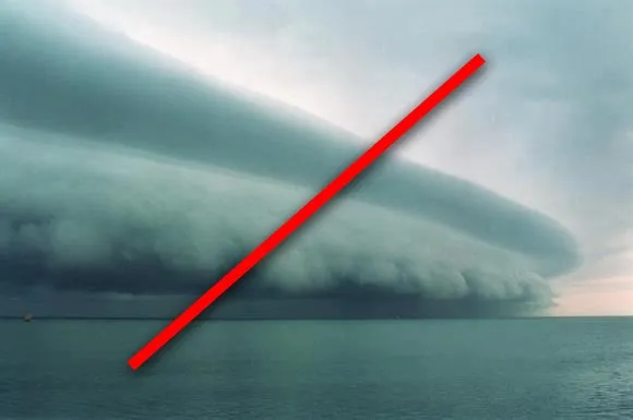
Similar fakery occurred last August during Hurricane Irene, when another photo of a supercell thunderstorm, superimposed on a picture of a Florida beach, got retweeted hundreds of thousands of times on Twitter. Likewise, in 2005, supercell storm pictures circulated as alleged shots of Hurricane Katrina making landfall.
This photo, allegedly a shot of Hurricane Irene approaching land in Aug. 2011, is Photoshopped.
(Image credit: Origin unknown)
Clearly, everyone likes the look of supercells. According to Chris Walcek, a meteorologist at the State University of New York, Albany, these impressive thunderclouds form in the Great Plains when a pocket of hot, vapor-filled air starts to rise in the presence of just the right amount of "wind shear," or change in wind speed with height. The huge air pocket starts to rotate, and the Coreolis force generated by the spin of the Earth enhances the air pocket's rotation.
"[T]he condensation pattern at cloud base forms a 'belt' or 'wall' appearance as air is lifted and sucked into the swirling storm," Walcek told Life's Little Mysteries back in May, when a spectacular supercell was photographed in Texas.
Sign up for the Live Science daily newsletter now
Get the world’s most fascinating discoveries delivered straight to your inbox.
By comparison, tropical storms and hurricanes are much less tightly packed and thus appear less beautifully structured in photographs — at least those taken at ground level. It takes a satellite to capture the terrifying magnificence of a churning hurricane.
Natalie Wolchover was a staff writer for Live Science from 2010 to 2012 and is currently a senior physics writer and editor for Quanta Magazine. She holds a bachelor's degree in physics from Tufts University and has studied physics at the University of California, Berkeley. Along with the staff of Quanta, Wolchover won the 2022 Pulitzer Prize for explanatory writing for her work on the building of the James Webb Space Telescope. Her work has also appeared in the The Best American Science and Nature Writing and The Best Writing on Mathematics, Nature, The New Yorker and Popular Science. She was the 2016 winner of the Evert Clark/Seth Payne Award, an annual prize for young science journalists, as well as the winner of the 2017 Science Communication Award for the American Institute of Physics.