It's quick and easy to access Live Science Plus, simply enter your email below. We'll send you a confirmation and sign you up for our daily newsletter, keeping you up to date with the latest science news.
Ernesto will continue to track through the Caribbean into early this week, bringing some gusty showers and thunderstorms to Jamaica through tonight before taking a turn toward the Belize and the Yucatan.
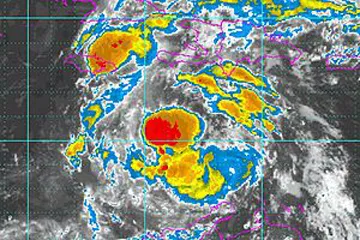
The system is expected to maintain tropical storm strength through the next few days as it continues to fight with some dry air located around the feature. Ernesto may encounter slightly more favorable conditions later Tuesday which could allow for brief strengthening before landfall occurs near Belize.
Drenching showers and thunderstorms will continue to affect Jamaica through tonight from Kingston to Negril and Montego Bay. Showers and a few thunderstorms will even linger through the first part of the day on Monday.
Localized rainfall totals of 2-4 inches are expected over Jamaica through today with some minor flooding a possibility. The highest amounts will occur in the higher elevations over the central part of the island.
In addition to the rain, tropical storm force wind gusts will affect the island through tonight with a few wind gusts of 30-40 mph. The strongest winds will occur over the southern coast closer to the center of circulation.
Rough surf will also continue throughout area beaches and a minor storm surge will occur on southern and eastern facing shores.
Sign up for the Live Science daily newsletter now
Get the world’s most fascinating discoveries delivered straight to your inbox.
Improving conditions over Jamaica are expected by tonight as Ernesto tracks west-northward toward Central America.
Ernesto will brush the coast of Honduras and northeastern Nicaragua today with tropical storm force winds and flooding downpours.
Due to the proximity to Central America, strengthening through tonight is unlikely.
Ernesto will continue on that west-northwest track on Tuesday before making landfall somewhere in Belize Tuesday night or early Wednesday morning.
After passing over the Yucatan during the middle of next week, Ernesto could emerge in the southern Gulf of Mexico as a slightly weakened feature or a tropical depression.
(Image credit: AccuWeather.com)
Residents along the Gulf Coast and in northeastern Mexico are urged to keep an eye on the progress of Ernesto as it could pose a threat to the U.S. late next week or next weekend.
Residents and visitors to Jamaica, Belize, Honduras and the Yucatan Peninsula should take proper precautions as Ernesto approaches. Flooding rains, mudslides and power outages are all likely to occur with this storm.
Keep checking back with AccuWeather.com as we continue to update you on the active Atlantic Ocean. Click here for the AccuWeather.com Hurricane Center and for the latest on Florence.

 Live Science Plus