Five days after the U.S. Army Corps of Engineers opened a flood control structure, or spillway, onto the Morganza Floodway, water had spread 15 to 20 miles (24 to 32 kilometers) southward across the Louisiana landscape.
As of May 18, a total of 17 bays on the spillway had been opened, with an estimated 114,000 cubic feet (3,200 cubic meters) per second flowing out of the Mississippi River and into the floodway. According to temporary gauges placed by the U.S. Geological Survey within the floodway, the water level at Tail Bay (the spillway) was 45.04 feet (13.7 m) above sea level as of 4:00 p.m. EDT on May 19. Downstream at U.S. Highway 190, the water level was 32.55 feet (9.9 m) as of 4:40 p.m. EDT on May 19. [Images: Before & After the 2011 Mississippi Floods ]
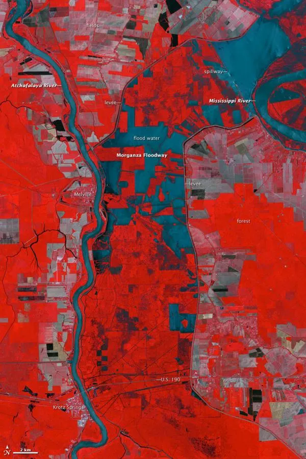
The leading edge of the flood water was about 3 miles (4.5 km) below Krotz Springs, between U.S. Route 190 and Interstate 10 (off the bottom of the image), according to Ricky Boyett, a spokesman for the Army Corps. Arrival at the Atchafalaya River is imminent, though the southward flow of water in the floodway has been slower than projections. The region had been suffering through a significant drought, so the ground and side waterways have been able to absorb more water than originally anticipated.
Latest Videos From
The Advanced Spaceborne Thermal Emission and Reflection Radiometer (ASTER) on NASA's Terra satellite captured this false-color image of the Morganza Floodway on May 18.
The falsecolor image combines infrared, red, and green wavelengths to help distinguish between water and land. Clear water is blue, and sediment-laden water is a dull blue-gray. Vegetation is red; the brighter the red, the more robust the vegetation. Gray patches away from the center of the floodway are likely farm fields that have recently been burned or cleared.
The floodway is bounded by a levee on the east side, and a levee and the Atchafalaya River on the west. The 800,000acre Atchafalaya Basin is the largest swamp in the United States, according to the U.S. Geological Survey.
Water is expected to reach Morgan City, near the coastal marshes of Louisiana, between May 21-23, according to news reports.