 Live Science Plus


Lingering Winter Chill Suppressing Tornadoes in 2013
This article was provided by AccuWeather.com.
A cool weather pattern from the Rockies to the East Coast has been helping to keep a lid on the number of tornadoes for 2013.
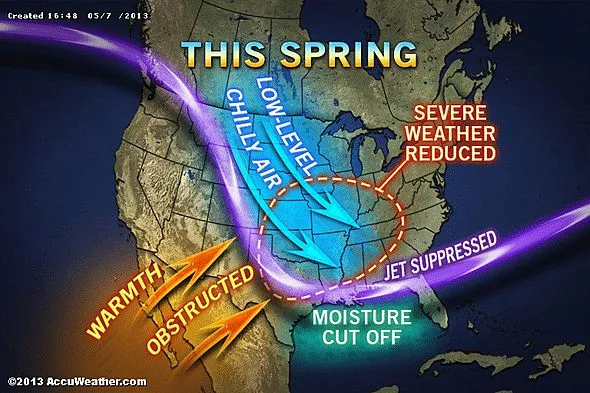
Article continues belowWhile a lack of moisture over the Plains and Midwest during a large part of 2012 worked to suppress the number of tornadoes in 2012, this spring it is unusually low temperatures over a broad area that are holding back the numbers.
Generally, the lower the temperature and/or the drier the air the lower the number of thunderstorms.
According to Harold Brooks, research meteorologist with NOAA's Severe Storms Laboratory, "The 12-month period from May 2012 to April 2013 was remarkable for the absence of tornado activity in the United States."
The preliminary data suggests that the period ending on April 30, 2013, brought an estimated 197 tornadoes of EF1 strength or greater.

"Since 1954, the previous low 12-month period was from June 1991 to May 1992, when 247 tornadoes with EF1 strength or greater occurred," Brooks stated in his blog.
The low count of tornadoes for 2013 so far may have something to do with the way large storms have been behaving coming out of the Rockies and moving onto the Plains.
RELATED: More Statistics from Jesse Ferrell Henry Margusity's Meteorological Madness AccuWeather.com's 2013 Summer Forecast
According to Severe Weather Expert Henry Margusity, "We have seen a swath of chilly air sweeping through low levels of the atmosphere, disturbing the way thunderstorms form over the Plains."
The wedge of cool air forces the base of the clouds from the thunderstorms to be higher off the ground.
This setup limits not only the number of tornadoes but also damaging wind gusts, since most of the action is occurring several thousand feet above the ground. The pattern can still produce a number of storms with hail.
According to Southern Weather Expert Dan Kottlowski, "We have seen a very persistent southward dip in the jet stream, shutting off the warm, humid flow from the Gulf of Mexico over much of the South during much of this spring."
The jet stream is a river of air high in the atmosphere that not only guides weather systems along but also often marks the boundary between warm air to its south and cold air to its north.
Kottlowski added that severe weather takes time to develop with several pieces having to fall into place before an outbreak can occur.
"There has been very little time for this to take place during much of the season with the exception of a major event during late January," Kottlowski said.
Will the Trend Continue?
As temperatures trend upward moving into the summer, there will be an inevitable general uptick in the number of thunderstorms, severe thunderstorms and tornadoes. However, with such a slow start and a continuation of the overall weather pattern into the first part of the summer, 2013 is likely to remain well behind the curve for violent thunderstorms and tornadoes.
A large southward dip in the jet stream is forecast to continue into the first part of the summer by AccuWeather.com long range forecasters.
As heat builds over the West, clusters of thunderstorms are projected to form over the northern Plains and drive southeastward across the Midwest into parts of the South and mid-Atlantic during June into July. While this expected pattern can bring severe weather, it generally favors thunderstorms with strong straight-line wind gusts over tornadoes.
According to Paul Pastelok, head of the AccuWeather.com long range team of meteorologists, "The intensity of these storms will be partially dependent on how much warm, low-level moisture from the Gulf of Mexico is able to feed into the advancing storms."
Ideally, warm, moist air at the surface, combined with a wedge of cool, dry air aloft, is ideal for severe thunderstorms, which can produce tornadoes.
AccuWeather.com. All rights reserved. More from AccuWeather.com.
The weather is getting stranger, right? Well, for the most part no, scientists say, but humans often think so when a strange event does occur. So here’s your chance to prove how much you known about weather oddities.
Weird Weather: One Strange Quiz

