
 Live Science Plus


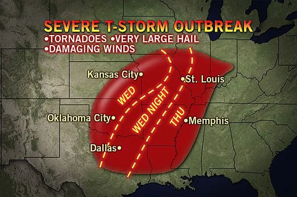
Dallas to St. Louis at Risk for Tornadoes
This article was provided by AccuWeather.com.
A major outbreak of severe thunderstorms is possible beginning Wednesday across the central and southern Plains. This could be one of the worst outbreaks of the year.
Cities with the greatest potential for severe weather into Wednesday night include Dallas, Wichita Falls, and Abilene, Texas, Oklahoma City and Tulsa, Okla., Chanute, Kan., and Joplin and Springfield, Mo., to name a few.

Dangerous severe thunderstorms are expected to develop during the early to mid-afternoon hours and continue well into the evening Wednesday.
Tornadoes will be the biggest danger with these storms. While not every storm will produce a tornado, those that do have the possibility to be rather strong and could be on the ground for an extended period.
According to Expert Senior Meteorologist Alex Sosnowski, "Unlike the setup last week where cold air undercut the prime area for thunderstorms, this time the air is not quite as cold and seems to be holding farther north and west."
"The setup last week yielded elevated thunderstorms (storms with the base of the clouds high off the ground) that were mostly hail producers," Sosnowski said. "Storms during the middle of this week over the Plains are likely to have a lower base and a greater risk of damaging wind and tornadoes along with an ongoing large hail threat."
Get the world’s most fascinating discoveries delivered straight to your inbox.
A southerly flow of moist air at the surface will shift to the west and become colder and drier higher above the ground. This shifting of wind with height, referred to by the weather community as wind shear, will contribute to the severity of the storms and may allow some of them to rotate. Rotating thunderstorms have a greater likelihood of producing a tornado.

Extremely large hail to the size of baseballs is possible across these areas. Hail of this size can kill people and animals and cause extreme property damage.
In addition to tornadoes and very large hail, wind gusts associated with these storms could exceed 60 mph and, in some cases, reach speeds of up to 70 or 80 mph. Blowing dust, uprooted trees and toppled power poles are possible.
On Thursday, the severe weather threat will develop farther east as a potent cold front moves along through the Mississippi Valley, overtaking a warm and humid flow of air from the Gulf of Mexico.
Thunderstorms will be ongoing Thursday morning from eastern Oklahoma through central Texas before spreading into the lower Mississippi River Valley Thursday afternoon and evening.
This threat Thursday will reach the area from Shreveport and Alexandria, La., to Little Rock, Ark., Memphis, Tenn., St. Louis, Mo.,, and Peoria, Ill.
Similar to what happened late last week, a large squall line could track across this region Thursday, bringing a widespread threat of wind damage. In addition, thunderstorms that pop up ahead of the main line could produce isolated tornadoes.
AccuWeather.com meteorologists are also concerned about a threat of flash flooding across the middle Mississippi River Valley and some of its tributaries Thursday as torrential downpours accompany the thunderstorms.
AccuWeather.com Expert Senior Meteorologist Jim Andrews stated that "The Mississippi River at St. Louis just crested at 6 feet below flood stage and an additional 1-3 inches of rain could lead to the river rising above flood stage."
Stay tuned to AccuWeather.com through early next week as we continue to monitor the potential for severe weather and river flooding.
Check out the Severe Weather Center for the latest watches and warnings.
Meteorologist Anthony Sagliani contributed to the content of this story.
© AccuWeather.com. All rights reserved. More from AccuWeather.com.
With much of the country experiencing an unseasonably warm winter, fears of climate change come to mind. See how well you understand recent weather, climate and the difference between them.
Weather vs. Climate Change: Test Yourself
